Blencathra - the Saddleback
A leisurely walk (mountain (above 600m)) in national park Lake District in Cumbria, England, about 6.60km (4.10 mi) long with an estimated walking time of about 3:45h. It is unsuitable for families with children, prams & pushchairs, wheelchairs.
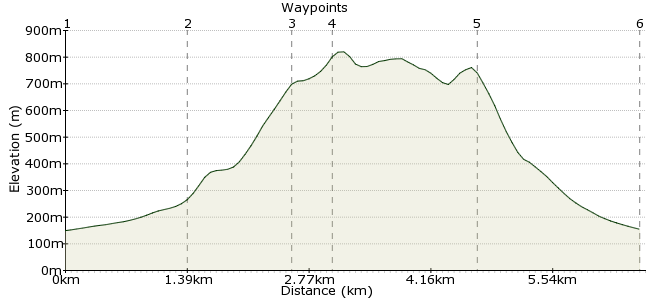
Elevation Profile


Ascent
667m (2188ft)
Descent
662m (2171ft)
Max. Elevation
830m (2723ft)
Altitude Gain & Loss
1329m (4359ft)
Start & End
Threlkeld
Distance
6.60km
(4.1mi)
(4.1mi)
Duration
~3:45h
Difficulty
Leisurely
Ordnance Survey Map
Of all the northern fells in the Lakes, Blencathra is undoubtedly one of the finest. There's something for everyone here - an easy and enjoyable hill walk for families, the classic scramble on Sharp Edge for those who like a challenge, and the finest pub the Lakes for when you finish in Threlkeld.
This walk starts and finishes in Threlkeld, and takes the walking way up. If you want to do Sharp Edge, ask the bus driver nicely if you can get off near Scales Farm.
Walk Functions
Share
Nearby Walks
Clough Head and Stybarrow Dodd
A strenuous, circular walk (mountain (above 600m)) starting in Cumbria, England, about 21.00km (13.05 mi) long, duration: ~8:15h.The old line to Threlkeld
A moderate, circular walk (riverside) starting in Cumbria, England, about 11.70km (7.27 mi) long, duration: ~4:15h.Make the most of Skiddaw
A moderate, circular walk (mountain (above 600m)) starting in Cumbria, England, about 16.50km (10.25 mi) long, duration: ~7:15h.Walk Map
- $walk->POI array(0)
Waypoints
OS Grid NY324254
From the village, head for the hamlet of Gategill, just northeast. There is a footpath starting opposite the first road junction.
OS Grid NY332266
From Gategill, a small track takes you underneath the imposing southern face of Blencathra. Don't worry - the route up is easier than it looks from here!
About 1.38 km (~0.86 miles) from 

OS Grid NY329277
From the farm, take the path heading up Doddick Fell. Head west when you get to the top of the ridge.
About 1.14 km (~0.71 miles) from 

OS Grid NY324277
The official summit of Blencathra! But it's really more of a summit plateau than a pointy top, so have a little wander over to Atkinson Pike and the view down Sharp Edge. Tempting for another day...?
About 0.49 km (~0.3 miles) from 

OS Grid NY311268
To descend, head along the southern edge of the plateau towards Blease Fell. From here you can pick up the track heading towards Blease Farm and continue into Threlkeld.
About 1.53 km (~0.95 miles) from 

OS Grid NY322254
The final stage provides the day's biggest challenge - which pub to head for? Opinion is divided among walkers, but either The Salutation Arms or the Horse and Farrier will be able to provide you with a delicious local beer (Jennings). Enjoy!
About 1.85 km (~1.15 miles) from 

 Back in Threlkeld
2 comments... join the discussion!
Tim Woods
Hi Raymond, yes, that's the beauty of Blencathra, there are many options for going up and down! That route down is also good.
Raymond Wilkes
We usually start at Scales, just east of Threlkeld. We descend via the Blencathra Centre and go via Brundholme Woods to Keswick