The Bridge of Orchy hills
A moderate walk (mountain (above 600m)) in Argyll and Bute, Scotland, about 11.10km (6.90 mi) long with an estimated walking time of about 6:00h. It is unsuitable for families with children, prams & pushchairs, wheelchairs.
Elevation Profile
Ascent
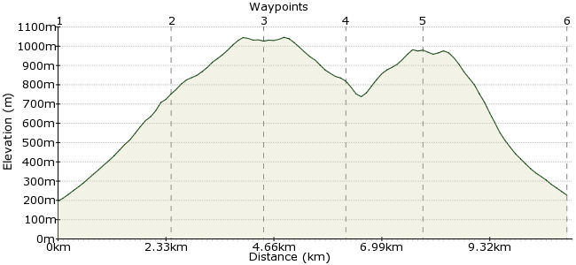
986m (3234ft)
Descent
955m (3133ft)
Max. Elevation
1050m (3444ft)
Altitude Gain & Loss
1941m (6367ft)
Start & End
Bridge of Orchy Station
Distance
11.10km
(6.9mi)
(6.9mi)
Duration
~6:00h
Difficulty
Moderate
Ordnance Survey Map
The twin peaks of Beinn an Dothaidh and Beinn Dorian are a fine day's walking, with the path leading up to them starting at Bridge of Orchy station - perfect for a car-free walk. It's a steep climb up, but the walking is easy once you reach the top. Navigation can be tricky in bad weather, though, as the rocky ground of the upper slopes soon becomes featurless.
Walk Functions
Share
Nearby Walks
Ben Lui from Tyndrum
A moderate, circular walk (mountain (above 600m)) starting in Stirlingshire, Scotland, about 15.70km (9.76 mi) long, duration: ~7:00h.Ben Oss and Beinn Dubhchraig
A moderate, circular walk (mountain (above 600m)) starting in Argyll and Bute, Scotland, about 18.10km (11.25 mi) long, duration: ~8:15h.Beinn Odhar and Meall Buidhe
A moderate, circular walk (mountain (above 600m)) starting in Stirlingshire, Scotland, about 8.50km (5.28 mi) long, duration: ~4:00h.Walk Map
- $walk->POI array(0)
Waypoints
OS Grid NN301394
From the station, a track leads up along the southern side of Allt Coire an Dothaidh. Easy route finding, as it sticks to the burn right up to the bealach between the peaks.
OS Grid NN325398
The bealach at the top of the burn is a good place to stop and take your bearings. Then head along the ridge of Am Fialach, which runs south towards Beinn Dorain.
About 2.41 km (~1.5 miles) from 
OS Grid NN325378
The day's first Munro - 1076m - is reached after about 2km. Retrace your steps back to the bealach.
About 2.00 km (~1.24 miles) from 
OS Grid NN324395
From the bealach, you need to head northeast towards the summit of Beinn an Dothaidh. The summit sits on the northern edge of the summit plateau across the boulder-strewn ground.
About 1.76 km (~1.09 miles) from 
OS Grid NN332409
The day's second peak, also a Munro at 1004m. You can see the ridge extending northeast to Beinn Achaladair and Bienn a' Chreachain. Return the way you came to the bealach and the path down.
About 1.52 km (~0.94 miles) from 
 Back to Bridge of Orchy
OS Grid NN303396
Return via the same path to Bridge of Orchy and the train home. There is a good walkers' bar in the Bridge of Orchy Hotel - popular with those doing the West Highland Way - and a bunkhouse if you need somewhere to sleep.
About 3.17 km (~1.97 miles) from 
