The northern fells - Great Calva, Knott and Carrock Fell
A hard walk (mountain (above 600m)) in national park Lake District starting and finishing in Cumbria, England, about 33.80km (21.00 mi) long with an estimated walking time of about 14:45h (1 overnight stay). It is unsuitable for families with children, prams & pushchairs, wheelchairs.
Elevation Profile
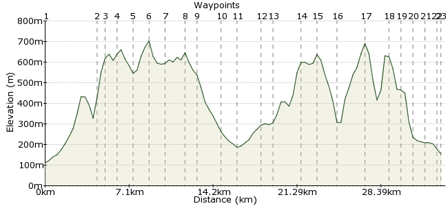
Ascent
1615m (5298ft)
Descent
1572m (5157ft)
Max. Elevation
710m (2329ft)
Altitude Gain & Loss
3187m (10455ft)
Start
Bassenthwaite
End
Threlkeld
Distance
33.80km
(21mi)
(21mi)
Duration
~14:45h
Difficulty
Hard
To be declared a fully-fledged Lake District expert, you need to spend at least a couple of days wandering around the oft-overlooked northern fells - Great Calva, Knott, Carrock Fell and their surrounding tops. Buses are sparse round here, so you will have to wander in and out from the south-eastern corner. There is good accommodation in Hesket Newmarket or Caldbeck to the north. It's also prime wild camping territory for those who prefer to sleep under canvas. NB: you need OS OL5 as well.
Walk Functions
Share
Nearby Walks
Among the giants - a valley walk in the Lakes
A moderate, linear walk (low hills and fells (below 600m)) starting in Cumbria, England, about 15.40km (9.57 mi) long, duration: ~5:30h.Barf and Lord's Seat from Whinlatter
A leisurely, circular walk (woodland) starting in Cumbria, England, about 6.40km (3.98 mi) long, duration: ~2:30h.The Coledale Horseshoe
A moderate, circular walk (low hills and fells (below 600m)) starting in Cumbria, England, about 12.60km (7.83 mi) long, duration: ~6:15h.Walk Map
- $walk->POI array(0)
Waypoints
OS Grid NY231324
Take the bus to Bassenthwaite village, with your rucksack packed for the two days. Take the bridleway heading east; this soon joins the Cumbria Way footpath.
OS Grid NY273313
The footpath takes you into the Dash Beck valley, between Bakestall and Little Calva. From here, you have a free reign in the access land - the route here is a suggestion, but the uncluttered hills are ideal for wandering as the mood takes you.
About 4.33 km (~2.69 miles) from 
OS Grid NY282315
Follow the slopes by Dry Gill onto Little Calva.
About 0.99 km (~0.62 miles) from 
OS Grid NY290311
It's a short hop over to the day's first big summit, Great Calva (690m). Cup of tea in the summit shelter (milk no sugar for me, thanks).
About 0.89 km (~0.55 miles) from 
OS Grid NY286323
Follow the eastern side of the top around to the dip between the Calvas and Burn Tod.
About 1.23 km (~0.76 miles) from 
OS Grid NY296329
From Burn Tod, climb the long slope of Knott to its summit (710m).
About 1.20 km (~0.75 miles) from 
OS Grid NY309339
Say on the high ground over Little Lingy Hill and onto Great Lingy Hill (they must have been running out of names by the time they got this far north).
About 1.57 km (~0.98 miles) from 
OS Grid NY319349
This is the highest point of the Caldbeck Fells, and the most northerly high point of the Lakes. From here, the land drops and spreads out towards the Solway Firth.
About 1.48 km (~0.92 miles) from 
OS Grid NY328357
From High Pike, you have a choice depending on your accommodation choice. A good option is Denton House in Hesket Newmarket: www.dentonhouseguesthouse.co.uk. Take the footpath heading northeast to reach the village. Otherwise, try in Caldbeck - follow the Cumbria Way north.
About 1.17 km (~0.73 miles) from 
OS Grid NY340372
The footpath leads to Wood Hall. Follow the road north for 300m, then take the footpath on the right-hand side to Hesket Newmarket.
About 2.00 km (~1.24 miles) from 
OS Grid NY340385
A lovely place to pass the evening, with views over the fells to enjoy in the evening.
About 1.30 km (~0.81 miles) from 
OS Grid NY338367
Start day two by retracing your steps past Wood Hall. Just beyond the hall, take the footpath heading southeast around the foot of the fells to Calebreck.
About 1.82 km (~1.13 miles) from 
OS Grid NY344358
At Calebreck, take the bridleway heading into the valley alongside Carrock Beck.
About 1.09 km (~0.68 miles) from 
OS Grid NY328342
The path leads on to Miton Hill. Head along the summit top to Carrock Fell.
About 2.26 km (~1.4 miles) from 
OS Grid NY341336
Continue along the top to Carrock Fell (649m). Once bagged, return to the cairn at Round Knott from where you can drop into the Grainsgill Beck valley.
About 1.44 km (~0.89 miles) from 
OS Grid NY326326
If legs are tiring, you can follow the Cumbria Way south out to Threlkeld from here. Otherwise, take the steep shoulder on to Bowscale Fell.
About 1.77 km (~1.1 miles) from 
OS Grid NY334306
It's a big long pull onto the summit (over 400m) but it's the last one of the trip, so enjoy!
About 2.12 km (~1.32 miles) from 
OS Grid NY339285
From Bowscale, it's possible to return via Blencathra, but this is a wilderness walk, so avoid the crowds by following Bannerdale Crags and descending via White Horse Bent.
About 2.19 km (~1.36 miles) from 
OS Grid NY343279
Cross the River Glenderamakin via the footbridge and take the path heading to Mousthwaite Comb.
About 0.73 km (~0.45 miles) from 
OS Grid NY342269
The last stretch heads round the southern foot of Blencathra. Follow the path through Scales ...
About 0.96 km (~0.6 miles) from 
OS Grid NY334264
... and through Doddick ...
About 0.97 km (~0.6 miles) from 
OS Grid NY325259
... and at Gategill, take the path into Threlkeld.
About 1.00 km (~0.62 miles) from 
 Threlkeld
OS Grid NY324254
Finish at Threlkeld and enjoy a well-earned pint in the Horse and Farrier Inn or the Salutation. Buses from Threlkeld towards Keswick or Penrith.
About 0.55 km (~0.34 miles) from 
