YHA Patterdale to YHA Grasmere
A moderate walk (mountain (above 600m)) in national park Lake District starting and finishing in Cumbria, England, about 12.20km (7.58 mi) long with an estimated walking time of about 5:30h. It is unsuitable for families with children, prams & pushchairs, wheelchairs.
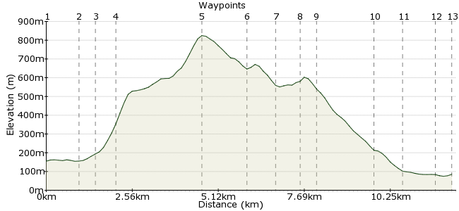
Elevation Profile


Ascent
714m (2342ft)
Descent
784m (2572ft)
Max. Elevation
830m (2723ft)
Altitude Gain & Loss
1498m (4914ft)
Start
Patterdale
End
Grasmere, Ambleside, Cumbria, England
Distance
12.20km
(7.58mi)
(7.58mi)
Duration
~5:30h
Difficulty
Moderate
Walk from Patterdale via St Sunday Crag and Grisedale Tarn and finish in Grasmere. An easy walk but some steep ascents. Excellent view from the top of St Sunday Crag.
Walk Functions
Share
Nearby Walks
High Street from Patterdale
A moderate, circular walk (mountain (above 600m)) starting in Cumbria, England, about 15.50km (9.63 mi) long, duration: ~6:30h.Place Fell from Patterdale
A moderate, circular walk (mountain (above 600m)) starting in Cumbria, England, about 9.80km (6.09 mi) long, duration: ~4:15h.St Sunday Crag and Hartsop over How
A moderate, circular walk (mountain (above 600m)) starting in Cumbria, England, about 11.50km (7.15 mi) long, duration: ~5:15h.Walk Map
- $walk->POI array(0)
Waypoints
OS Grid NY399156
Start from the YHA and follow the main route; turn left after the church.
OS Grid NY390161
Follow a single lane road
then turn at the first gate after Close Cottage.
About 0.98 km (~0.61 miles) from 

OS Grid NY386158
Follow a grass path then turn right onto a steep path.
About 0.49 km (~0.3 miles) from 

OS Grid NY385153
An extremely steep path!
About 0.51 km (~0.32 miles) from 

OS Grid NY369134
The path gets easier along Black Crag. A steep path after towards the summit and a long plateau to the top.
About 2.53 km (~1.57 miles) from 

OS Grid NY359123
A steep descent towards the tarn; turn right at the pile stone (left to Fairfield).
About 1.40 km (~0.87 miles) from 

OS Grid NY352121
A steep descent followed by the passage through a bog
and arrive at the tarn.
About 0.77 km (~0.48 miles) from 

OS Grid NY348116
A light ascent above the tarn and down towards Grasmere.
About 0.62 km (~0.39 miles) from 

OS Grid NY348112
Descent towards Grasmere then
turn left towards Tongue Gill.
About 0.43 km (~0.27 miles) from 

OS Grid NY340097
A steep descent to start followed by a long calm descent.
About 1.65 km (~1.03 miles) from 

OS Grid NY336091
Pass a bridge and follow a straight descent towards the main road.
About 0.80 km (~0.5 miles) from 

OS Grid NY339082
Follow the main road then turn left.
About 0.94 km (~0.58 miles) from 

OS Grid NY336078
Follow the path through the village centre to arrive at the YHA.
About 0.45 km (~0.28 miles) from 

 YHA Grasmere