Conwy Falls-Penmachno-Betws
A moderate walk (countryside) in national park Snowdonia starting and finishing in Gwynedd, Wales, about 11.80km (7.33 mi) long with an estimated walking time of about 4:00h. It is suitable for families with children, but unsuitable for prams & pushchairs, wheelchairs.
Elevation Profile
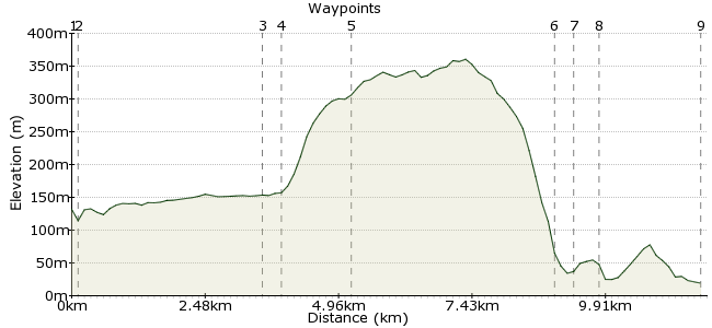
Ascent
187m (613ft)
Descent
299m (980ft)
Max. Elevation
370m (1213ft)
Altitude Gain & Loss
486m (1593ft)
Start
Conwy Falls
End
Betws-Y-Coed
Distance
11.80km
(7.33mi)
(7.33mi)
Duration
~4:00h
Difficulty
Moderate
Ordnance Survey Maps
 1Created by driver 16 on 20 Sep 2015
Walk into main village in Machno Valley on quite quiet country road 30%, very quiet country lanes 30% keeping on right facing traffic and deserted forest tracks 40% and back into Betws-y-Coed, outstanding views and sounds of running water and wildlife, fantastic.
Walk Functions
Share
Nearby Walks
Fairy Glen and Conway Falls
A leisurely, circular walk (riverside) starting in Gwynedd, Wales, about 4.40km (2.73 mi) long, duration: ~1:30h.Along the Afon Llugwy
A leisurely, linear walk (riverside) starting in Clwyd, Wales, about 8.10km (5.03 mi) long, duration: ~3:00h.The old slate mines - exploring Snowdonia's history
A leisurely, linear walk (woodland) starting in Clwyd, Wales, about 7.70km (4.78 mi) long, duration: ~3:00h.Walk Map
- $walk->POI array(0)
Waypoints
OS Grid SH810535
Conwy Falls Café, can walk in grounds to see falls for a nominal charge, also new meeting point for adventure tours of old caves Go Below.
OS Grid SH810533
Leaflet I was working on said there was a footpath sign on left, NO ARROW, remains of path looked very overgrown, so, felt safer on main road, but, no footpath, so, stay on right facing oncoming cars.
About 0.20 km (~0.12 miles) from 
OS Grid SH790505
After passing cows, horses, sheep and outstanding views over valley cross bridge into centre of village.
About 3.38 km (~2.1 miles) from 
OS Grid SH789506
Follow twists and turns, pass entrance to Ty Mawr, watch for sign on right KEEP OUT DEEP MINE, short distance to sharp right turn onto stoney narrow path uphill.
About 0.21 km (~0.13 miles) from 
OS Grid SH775508
Climb uphill path widens into forest track cross driveway to Ty Mawr ahead onto next track, first T junction turn right second T junction turn left down to meet tarmac lane turn left.
About 1.34 km (~0.83 miles) from 
OS Grid SH798538
Bear right downhill to meet main road.
About 3.70 km (~2.3 miles) from 
OS Grid SH796541
Cross to right onto footpath / cycle track, follow to waypoint 8.
About 0.40 km (~0.25 miles) from 
OS Grid SH796546
Brings you out onto main road in Betws, turn left, cross and onto Station / Bus Stop end of walk.
About 0.48 km (~0.3 miles) from 
 Station/bus stop
OS Grid SH794565
End of longer walk than had planned, but, still enjoyed, hope you do too.
About 1.90 km (~1.18 miles) from 
