The Pymmes Brook Trail
A moderate walk (city/town) starting and finishing in City of London, England, about 16.40km (10.19 mi) long with an estimated walking time of about 4:30h. It is suitable for prams & pushchairs, wheelchairs, but unsuitable for families with children.
Elevation Profile
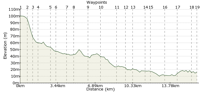
Ascent
6m (19ft)
Descent
90m (295ft)
Max. Elevation
110m (360ft)
Altitude Gain & Loss
96m (314ft)
Start
Cockfosters Tube Station
End
Pickett's Lock
Distance
16.40km
(10.19mi)
(10.19mi)
Duration
~4:30h
Difficulty
Moderate
Ordnance Survey Map
This signposted walk runs for ten miles through the parks and suburbs of north London as it follows (roughly) the course of Pymmes Brook, a tributary of the River Lea. This guide gives you an overview of the route; for a more detailed guide to the walk, contact Barnet Council for a free trail leaflet:
www.barnet.gov.uk/walks
As ever in London, there are excellent transport links to the start and finish points, and along the way. It's useful to pop a London street atlas in the rucksack.
Walk Functions
Share
Nearby Walks
The end of the line...but worth it!
A leisurely, circular walk (countryside) starting in City of London, England, about 6.20km (3.85 mi) long, duration: ~1:45h.The Parkland Walk
A leisurely, linear walk (city/town) starting in City of London, England, about 6.00km (3.73 mi) long, duration: ~1:45h.Hampstead, London
A leisurely, circular walk (city/town) starting in City of London, England, about 5.30km (3.29 mi) long, duration: ~1:30h.Walk Map
- $walk->POI array(0)
Waypoints
OS Grid TQ281964
Take the tube or the bus to Cockfosters.
OS Grid TQ274967
Pick up the trail at the end of Games Road. From here, the blue arrow markers will guide you all the way along the route; rather than giving step-by-step instructions, this guide provides a handy overview.
About 0.75 km (~0.47 miles) from 
OS Grid TQ270969
The route follows the London Loop past Beech Hill Lake, the source of the brook.
About 0.42 km (~0.26 miles) from 
OS Grid TQ268965
Leave the brook and pass through Victoria Recreation Ground. From the southeast corner, head along Crescent Road, which lies just south of the brook (although you can't see it).
About 0.47 km (~0.29 miles) from 
OS Grid TQ271956
Turn left at Brookhill Road and then right onto Cat Hill.
About 0.98 km (~0.61 miles) from 
OS Grid TQ273950
Rejoin the brook as it runs through Oak Hill Park. Remind yourself how lucky London is to have so many lovely parks.
About 0.57 km (~0.35 miles) from 
OS Grid TQ281945
Leave the park on the southern side and head along West Walk.
About 0.92 km (~0.57 miles) from 
OS Grid TQ284941
Cross Osidge Lane and into Brunswick Park.
About 0.51 km (~0.32 miles) from 
OS Grid TQ292930
Across Waterfall Road, the Pymmes Brook enters Arnos Park.
About 1.36 km (~0.85 miles) from 
OS Grid TQ302926
Head north a short way and walk along the southern edge of Broomfield Park. At the end, follow Broomfield Lane over the railway and onto Oakthorpe Road.
About 1.08 km (~0.67 miles) from 
OS Grid TQ315920
This little section is a wee bit tricky - keep an eye on the arrows as you cross over the North Circular and join Princes Avenue.
About 1.46 km (~0.91 miles) from 
OS Grid TQ321923
The route continues along Tile Kiln Lane.
About 0.62 km (~0.39 miles) from 
OS Grid TQ326925
The brook can't make its mind up, heading back under the main road. At Silver Street, it passes through the grounds of the Millfields Arts Centre.
About 0.62 km (~0.39 miles) from 
OS Grid TQ337925
The next bit of green is Pymmes Park.
About 1.02 km (~0.63 miles) from 
OS Grid TQ339930
Leave via Park Road and head onto Fore Street, turning left up to Plevna Road.
About 0.56 km (~0.35 miles) from 
OS Grid TQ351932
The trail heads along Salmon's Brook and past Tottenham Park Cemetery.
About 1.18 km (~0.73 miles) from 
OS Grid TQ360938
Head up to Pickett's Loch Lane. Continue on to the William Girling Reservoir, where the trail ends.
About 1.13 km (~0.7 miles) from 
OS Grid TQ363950
For an additional bonus, head along the Lea Valley Walk on the western edge of the reservoir.
About 1.24 km (~0.77 miles) from 
 Ponders End
OS Grid TQ360955
Finish your day at Ponders End station, for the train onwards.
About 0.55 km (~0.34 miles) from 
