The Coledale Horseshoe
A moderate walk (low hills and fells (below 600m)) in national park Lake District in Cumbria, England, about 12.60km (7.83 mi) long with an estimated walking time of about 6:15h. It is unsuitable for families with children, prams & pushchairs, wheelchairs.
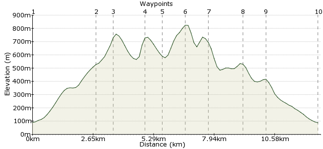
Elevation Profile
Ascent
902m (2959ft)
Descent
904m (2965ft)
Max. Elevation
830m (2723ft)
Altitude Gain & Loss
1806m (5924ft)
Start & End
Braithwaite
Distance
12.60km
(7.83mi)
(7.83mi)
Duration
~6:15h
Difficulty
Moderate
Ordnance Survey Map
Tucked up in the northwest corner of the Lakes, this great walk takes in the horseshoe of peaks sitting around Coledale Beck - Grisedale Pike, Hopegill Head, Crag Hill, Sail and Outerside. Buses to Braithwaite from Keswick; for an alternative (linear) route, you could take the bus to Buttermere instead and approach the horseshoe via Whiteless Pike.
Walk Functions
Share
Nearby Walks
Barf and Lord's Seat from Whinlatter
A leisurely, circular walk (woodland) starting in Cumbria, England, about 6.40km (3.98 mi) long, duration: ~2:30h.The Newlands Round
A moderate, linear walk (mountain (above 600m)) starting in Cumbria, England, about 17.90km (11.12 mi) long, duration: ~7:00h.Little Man and Glenderaterra Beck
A moderate, circular walk (mountain (above 600m)) starting in Cumbria, England, about 15.70km (9.76 mi) long, duration: ~6:45h.Walk Map
- $walk->POI array(0)
Waypoints
OS Grid NY232236
The footpath from Braithwaite to Grisedale Pike starts in the village, climbing steadily up the long north-eastern shoulder of the hill.
OS Grid NY204227
Keep on past Sleet How towards the summit.
About 2.84 km (~1.76 miles) from 
OS Grid NY198225
The summit of Grisedale Pike (791m) is an excellent vantage point from which to survey the northern fells.
About 0.62 km (~0.39 miles) from 
OS Grid NY187219
Continue past Hobcarton Crag to Hopegill Head.
About 1.32 km (~0.82 miles) from 
OS Grid NY189212
Drop into Coledale Hause via Sand Hill. It's then a scrambly climb up past Eel Crag onto Crag Hill.
About 0.71 km (~0.44 miles) from 
OS Grid NY191203
This is the highest point of the day at 839m.
About 0.98 km (~0.61 miles) from 
OS Grid NY200204
Keep heading around the glacially-carved horseshoe to Sail.
About 0.90 km (~0.56 miles) from 
OS Grid NY211214
The descent passes two small hummocks, including Outerside. It's also possible to visit nearby Barrow on route to Braithwaite.
About 1.51 km (~0.94 miles) from 
OS Grid NY221217
The path runs between Barrow and Stile End as it weaves back to the village.
About 0.95 km (~0.59 miles) from 
 Back to Braithwaite
OS Grid NY233235
Finish in Braithwaite, which has three pubs to choose from. The Coledale Inn is the popular walkers' choice.
About 2.21 km (~1.37 miles) from 
