In the heart of Thomas Hardy's Dorset
A moderate walk (countryside) in Dorset, England, about 14.40km (8.95 mi) long with an estimated walking time of about 4:45h. It is suitable for families with children, but unsuitable for prams & pushchairs, wheelchairs.
Elevation Profile
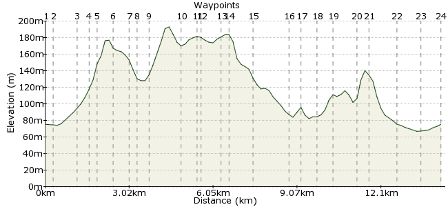
Ascent
237m (777ft)
Descent
237m (777ft)
Max. Elevation
200m (656ft)
Altitude Gain & Loss
474m (1554ft)
Start & End
Chetnole Station
Distance
14.40km
(8.95mi)
(8.95mi)
Duration
~4:45h
Difficulty
Moderate
Ordnance Survey Map
 Car Free Walks TeamCreated by GaryShipp on 18 Sep 2011
A walk for anyone wishing to explore this quite area of rural Dorset. It offers something for everyone - exhilarating views, historical points of interest, gorgeous villages and lovely country pubs. A little taste of rural England.
The walk is described from Chetnole Station on the Weymouth to Bristol 'Heart of Wessex' line. However, you can also join along the route at Melbury Osmund and Evershot using bus number 212 that runs between Yeovil, Maiden Newton and Dorchester (weekends appear to be more frequent but check the timetable).
Walk Functions
Share
Nearby Walks
Dorset wanderings - Yetminster to Thornford
A leisurely, circular walk (countryside) starting in Dorset, England, about 5.00km (3.11 mi) long, duration: ~1:30h.Around Maiden Newton
A leisurely, circular walk (countryside) starting in Dorset, England, about 6.70km (4.16 mi) long, duration: ~2:00h.Five village circular walk starting at Barrington
A moderate, circular walk (countryside) starting in Somerset, England, about 11.90km (7.39 mi) long, duration: ~3:30h.Walk Map
- $walk->POI array(0)
Waypoints
OS Grid ST597076
On the line between Bristol and Weymouth, this station is 'by request', so make sure you let the train conductor that you wish to alight here.
OS Grid ST601076
The entrance to the field could be mistaken for someone's garde, so keep your eye out for the sign.
About 0.38 km (~0.24 miles) from 
OS Grid ST597068
Cross the bridge, go through the gate and then diagonally across the field.
About 0.84 km (~0.52 miles) from 
OS Grid ST595065
Sited next to the Manor House, St Mary's Church has an unusual font with carved animals on the stone, placed upside down. More info here - http://bit.ly/nf4Qs5
About 0.34 km (~0.21 miles) from 
OS Grid ST592067
Beautiful 270 degree views, from Gore Hill in the SE to the North and possible the Mendips in the far, far distance?
About 0.28 km (~0.17 miles) from 
OS Grid ST589064
Look out for the sign pointing the footpath off to the left. This is a gorgeous, native deciduous woodland which is likely awash with bluebells in the spring. Will have to return then to confirm! The only spoliing feature here is the presence of traffic noise from the nearby road.
About 0.47 km (~0.29 miles) from 
OS Grid ST588059
Fast traffic but good visibility - take care. Head straight over and look for the gate into the small coniferous plantation. Strangely the online OS map doesn't show a bridleway where, whereas it exists on printed versions and signs are definately in place so don't be put off.
About 0.51 km (~0.32 miles) from 
OS Grid ST586058
Follow the path to the botton of the hill and join the track at the woodland corner.
About 0.23 km (~0.14 miles) from 
OS Grid ST582057
The land round here is part of the estate surrounding Melbury House, which you'll pass by later.
About 0.40 km (~0.25 miles) from 
OS Grid ST575048
If you're in a hurry, turn right now to short cut the walk and miss out waypoints 11 and 12. However, we'd recommend the diversion into the delightful village of Evershot.
About 1.14 km (~0.71 miles) from 
OS Grid ST571045
Site of the old village well, water is still drawn by the nearby estate. Information boards provide some interesting history and the nearby stream a pleasant accompaniment to rest break.
About 0.49 km (~0.3 miles) from 
OS Grid ST572044
Finding fame in the film 'Emma', this is a delightful little village - the 2nd highest in Dorset. The Acorn Inn is the last remaining of 8 public houses, but offers fantastic accommodation as well as fine food and liquid refreshment. A stop in the wamr and friendly bar is highly remcommended. The viallge also has a small grocery shop/post office and a bakers. Having explored, head back to waypoint 10.
About 0.18 km (~0.11 miles) from 
OS Grid ST574051
You'll have to look a little closely for the footpath entrance to the estate grounds which is in the shrubs to the right of the imposing gates across the drive. We haven't managed to discover hhe relevance of the foxes adorning the gates.
About 0.69 km (~0.43 miles) from 
OS Grid ST573054
Keep to the drive as you walk through the estate. The grounds contain some magnificent trees that were stunning in Aumtumnal colours, and views across acres and acres of park land.
About 0.30 km (~0.19 miles) from 
OS Grid ST575061
the house is still a private residence, so the closest you can get to the the front of the house is at the point where the drive curves away from the house and continues nortwards. Looking back you will get a tantalising view of the house, where apparently there a particularly magnificent view from within the hexagonal tower which lies at the intersection of three wings of the house. The house has remained in the same family since the 1500.
About 0.73 km (~0.45 miles) from 
OS Grid ST575074
Having followed the drive to the end of the estate you arrive in the attractive village of Melbury Osmond at Town End farm.
About 1.34 km (~0.83 miles) from 
OS Grid ST573077
The village has many attractive buildings and a history dating back to pre-Domesday. According to the information board in the village centr,e the name 'Melbury' is derived from two Saxon words: 'Mel' meaning many coloures and 'Bury' meaning earthwork.
About 0.35 km (~0.22 miles) from 
OS Grid ST576075
Depending which way you choose to leave the village, you could quite easily miss this unusual feature. Under the road heading to Town Farm is a carfully constructed tunnel which must have an interesting history of purpose. It's obvious from the the footpath heading directly from the thatched cottage next to to Town Farm itself, but approaching from tthe north, it is hard to spot and you'll find yourself encroaching on private land. Look out for the gate to the permissive path that takes you to the right of way under the road.
About 0.40 km (~0.25 miles) from 
OS Grid ST582072
Keep your wits about you here as the traffic is fast moving and there's no footway alongside the road. The footpath down and across the fields starts at a metal 5-bar gate.
About 0.61 km (~0.38 miles) from 
OS Grid ST589069
Apparently the smallest church in Dorset and maybe the second smallest in England and measuring 29ft long and 12ft 9 wide. We're not sure of the access arrangement as the church is is very close proximity to the nearby house. Further info about the church can ve found here -
http://tiny.ly/Rb0m
About 0.77 km (~0.48 miles) from 
OS Grid ST592067
A little bit of careful navigation will take you up the steep sides of Budd Down to close by the trig point you visited earlier. From here you can retrace your steps to Melbury Bubb or take the more direct path back towards Chetnole, crossing the railway line at track height. If the later, take care and follow the warning instructions, remembering the single-track line operates in both directions.
About 0.37 km (~0.23 miles) from 
OS Grid ST599075
Trains are not particularly frequent from Chetnote station, so depending on the wait, you might like to explore the village, the attractive 15th century church and historic 'The Court'. If pushed for time, head down the road back to the station.
About 1.07 km (~0.66 miles) from 
OS Grid ST601082
Closed when we visited on a weekday afternoon, but apparently a reputation for excellent food - a sign outside claimed 'Best dining pub in Dorset' in the Taste of Dorset awards 2010 and 2011.
About 0.73 km (~0.45 miles) from 
 Chetnole Station
OS Grid ST596076
Remember the station is 'by request', so you'll need to hail the driver as the driver approaches to ensure the train stops for you.
About 0.80 km (~0.5 miles) from 
