Whitby to Runswick Bay
A moderate walk (coast) in national park North York Moors starting and finishing in North Yorkshire, England, about 12.00km (7.46 mi) long with an estimated walking time of about 3:45h. It is unsuitable for families with children, prams & pushchairs, wheelchairs.
Elevation Profile
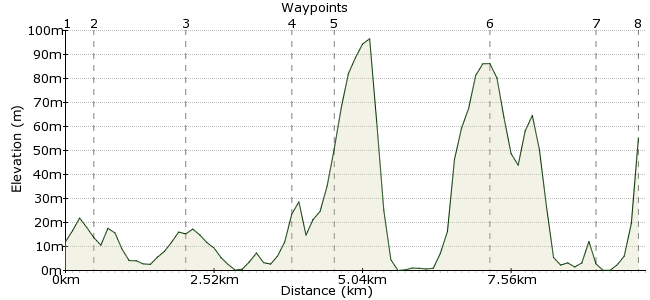
Ascent
97m (318ft)
Descent
54m (177ft)
Max. Elevation
100m (328ft)
Altitude Gain & Loss
151m (495ft)
Start
Whitby
End
Runswick
Distance
12.00km
(7.46mi)
(7.46mi)
Duration
~3:45h
Difficulty
Moderate
Ordnance Survey Map
Another coastal classic in North Yorkshire, from Whitby to Runswick Bay. Regular buses make the connections easy, and the walk is nothing too taxing either. It's worth adding a bit of extra time to your plans to hunt for fossils on the beaches too.
Walk Functions
Share
Nearby Walks
The Murk Esk in the North York Moors
A leisurely, circular walk (countryside) starting in North Yorkshire, England, about 6.10km (3.79 mi) long, duration: ~2:00h.Goathland to Grosmont
A leisurely, linear walk (countryside) starting in North Yorkshire, England, about 6.20km (3.85 mi) long, duration: ~1:45h.Danby
A leisurely, circular walk (countryside) starting in North Yorkshire, England, about 8.50km (5.28 mi) long, duration: ~2:45h.Walk Map
- $walk->POI array(0)
Waypoints
OS Grid NZ897108
Start at Whitby, famous for its Dracula associations. No vampire puns here though, there's too much at stake.
OS Grid NZ898114
Head down to the seafront, where you will see signs for the Cleveland Way.
About 0.61 km (~0.38 miles) from 
OS Grid NZ881119
At the end of the esplenade, drop down to walk along the beach.
About 1.71 km (~1.06 miles) from 
OS Grid NZ860128
At the village of Sandsend, pick up the Cleveland Way once more.
About 2.29 km (~1.42 miles) from 
OS Grid NZ859137
This is where things get (even more) interesting. The Cleveland Way follows the rocky coastline of the North York Moors, starting with Sandsend Ness.
About 0.90 km (~0.56 miles) from 
OS Grid NZ836158
Continue along the coastline to Kettle Ness, and the nearby village of Kettleness. Which was named first, I wonder?
About 3.04 km (~1.89 miles) from 
OS Grid NZ815154
At Hob Holes, there is a short descent which has a rope to help you climb down to the beach.
About 2.16 km (~1.34 miles) from 
 Runswick Bay
OS Grid NZ809161
From the beach head on to the village of Runswick Bay for the bus back to Whitby.
About 0.95 km (~0.59 miles) from 

3 comments... join the discussion!
Annie
Are dogs allowed on buses between Whitby and Runswick bay? It would be useful to know please. Thank you.
Adrian Lohrey
I found the walk very enjoyable and well signposted. Care is needed on the last part of the descent onto the beach because there has been some storm damage to the provided path furniture.
Ken Morgan
Too much at stake....i like it. Thanks for an interesting walk with good info and directions