Presteigne to Kington – Offa Hoppa Walk 3
A moderate walk (low hills and fells (below 600m)) starting and finishing in Powys, Wales, about 12.20km (7.58 mi) long with an estimated walking time of about 4:15h. It is unsuitable for families with children, prams & pushchairs, wheelchairs.
Elevation Profile
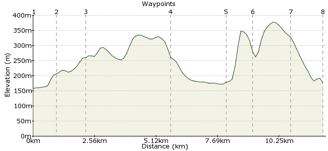
Ascent
254m (833ft)
Descent
236m (774ft)
Max. Elevation
380m (1246ft)
Altitude Gain & Loss
490m (1607ft)
Start
Presteigne
Distance
12.20km
(7.58mi)
(7.58mi)
Duration
~4:15h
Difficulty
Moderate
Ordnance Survey Map
An energetic 9.5 mile linear walk on bridleways and quiet lanes to Offa’s Dyke Path then a steep climb over Herrock, across Rushock and Bradnor hills to descend into Kington.
Walk Functions
Share
Nearby Walks
Norton to Knighton - Offa Hoppa Walk 4
A leisurely, linear walk (low hills and fells (below 600m)) starting in Powys, Wales, about 7.00km (4.35 mi) long, duration: ~2:30h.Titley to Kington - Offa Hoppa Walk 2
A leisurely, linear walk (low hills and fells (below 600m)) starting in Herefordshire, England, about 7.00km (4.35 mi) long, duration: ~2:30h.Walton to Kington - Offa Hoppa Walk 1
A leisurely, linear walk (low hills and fells (below 600m)) starting in Powys, Wales, about 7.70km (4.78 mi) long, duration: ~2:45h.Walk Map
- $walk->POI array(0)
Waypoints
OS Grid SO315640
The Offa Hoppa 41/461 from Kington to Knighton will drop you in Presteigne at the Recycling Centre. Cross Joe Deakins Road into Station Road (signed to Town Centre) and then turn left into Hereford Street (there’s also a bus stop by the Police Station, car park and toilets on Hereford Street). Keep ahead into High Street, unless you want to detour to the excellent Judge’s Lodging and Chambers along Broad Street. Pass by the Radnorshire Arms Hotel and, just after a filling station, follow High Street left up to Joe Deakins Road again (signed to The Warden). Cross over into Warden Road where you can access the Warden, the earthworks of an old motte and bailey castle.
OS Grid SO306644
The road starts to bend right, and just after an information board and gate into The Warden go left on a no through road, signed as a bridleway. Continue in the same direction past Harley Farm, where the road becomes a track which can get muddy in places. This gives out to a grassy swathe up to a junction and fingerpost beneath Harley’s Hill where you head half right across a pasture. The views across Presteigne to Mortimer Forest are exceptional from here. Keep at about the same height and look on your right for a stile to the left of a group of three trees in a hazel hedge. Cross this stile and proceed ahead across the field to cross another onto a lane.
About 0.94 km (~0.58 miles) from 
OS Grid SO294647
Go left on a gated road, with gorse hedgerows, to pass Rowley Farm and then descend to the hamlet of Thorn where you cut left on a signed byway at a cross roads just before a large barn on your left. This rises to a summit to offer some super views and then descends to a house by a junction. Go ahead on the road and it soon passes an old quarry and woodland where you join Offa’s Dyke Path, which crosses the road.
About 1.26 km (~0.78 miles) from 
OS Grid SO268624
Go left up steps and through a bridle gate to run along a line of trees to a gate by a barred gate. The path is clear on the ground following either side of a fence for about a mile through to Burfa where it descends steps and through a bridle gate onto a road. Go left and then next right here to pass by Old Burfa a beautifully restored medieval farmhouse. Follow the track ahead and it joins a more prominent forestry track and then ahead on a road (there’s a signpost to Rushock Hill here). Go right opposite a house to cross an ancient stone bridge and then onward along the B4362 road (be very careful on this section) to Lower Harpton.
About 3.50 km (~2.17 miles) from 
OS Grid SO276602
Before the farm buildings turn left on a track and past the buildings turn right through a gate; go slightly left across a pasture to go through a second bridle gate. Turn left here to walk by a house and through a gate and onward on a track which bends right through another gate to pass a barn on the right. The track forks so keep right here to climb more steeply up the hillside to an interpretation board and signpost on Herrock Hill.
About 2.26 km (~1.4 miles) from 
OS Grid SO281593
Go left to a stile by a barred gate and ahead on a green track to cross the next stile. Walk by the earthworks to cross a stile and keep ahead to a waymark post indicating to go right. Go left to a stile by a barred gate and ahead on a green track to cross the next stile. Walk by the earthworks to cross a stile and keep ahead to a waymark post. Cross a stile by a gate and turn three quarters left to go down the pasture to another stile. Cross this and head slightly left towards a line of hawthorns. As the hedge bends left, keep ahead, then go through a gate in the hedge in front of you. In the next field head half left to go through a gate. The path bends slightly left and climbs to a stile. Cross it and go slightly right up to a stile. Cross this and go half left, aiming towards the wood which you pass. Cross a stile by a gate, continue slightly right to cross a stile into the golf course at Bradnor Hill, then go left to a gate onto a road.
About 1.05 km (~0.65 miles) from 
OS Grid SO288579
Go left at the junction but after 40 yards cut slightly right between greens to descend to a signpost with the clubhouse to the left. Go down the hill, passing cottages on your left. Cross a track just to the left of a white house, and descend a grassy patch through a gate onto a narrow path. Continue downhill through kissing gates and gates until you reach a tarmac lane. Go left down to the main A44 road. Cross with care, go over the footbridge and turn left to walk along a lane.
About 1.57 km (~0.98 miles) from 
 Kington
OS Grid SO291566
Go ahead at the cross roads and at the next junction turn left to pass St John House on your right and then turn right into The Square. Go left on the main road to the Town Hall where you turn right for Mill Street bus stops.
About 1.37 km (~0.85 miles) from 
