The Grand Union Canal in Herts
A leisurely walk (canal) in Aylesbury Vale, England, about 9.60km (5.97 mi) long with an estimated walking time of about 2:45h. It is unsuitable for families with children, prams & pushchairs, wheelchairs.
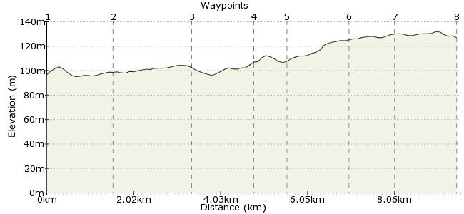
Elevation Profile


Ascent
34m (111ft)
Descent
3m (9ft)
Max. Elevation
140m (459ft)
Altitude Gain & Loss
37m (120ft)
Start & End
Cheddington
Distance
9.60km
(5.97mi)
(5.97mi)
Duration
~2:45h
Difficulty
Leisurely
Ordnance Survey Map
This Hertfordshire walk takes in an enjoyable stretch of the Grand Union Canal in Hertfordshire. The route runs between two stations, Cheddington and Tring, but there are several buses serving the nearby towns as well. There's a cracking pub halfway along as well, so worth planning your day to include a stop there.
Walk Functions
Share
Nearby Walks
Aldbury circular walk
A leisurely, circular walk (countryside) starting in Hertfordshire, England, about 6.40km (3.98 mi) long, duration: ~2:15h.Quick hour walking about on Coombe Hill
A leisurely, circular walk (low hills and fells (below 600m)) starting in Buckinghamshire, England, about 5.10km (3.17 mi) long, duration: ~1:45h.Berkhamsted Common
A leisurely, circular walk (woodland) starting in Hertfordshire, England, about 7.00km (4.35 mi) long, duration: ~2:15h.Walk Map
- $walk->POI array(0)
Waypoints
OS Grid SP921185
Take the train to Cheddington.
OS Grid SP933176
Cross under the main road at Ivinghoe Bridge.
About 1.51 km (~0.94 miles) from 

OS Grid SP926159
Under the railway line and on to Cooks Wharf.
About 1.78 km (~1.11 miles) from 

OS Grid SP918147
Time for a pint. Head for the Red Lion, just a short hop from the canal: www.thegoodpubguide.co.uk/pub/view/Red-Lion-HP23-4LU
About 1.49 km (~0.93 miles) from 

OS Grid SP919140
Cross over the bridge in Marsworth to rejoin the canal path.
About 0.66 km (~0.41 miles) from 

OS Grid SP933136
If time allows, take a short diversion to the College Lake Wildlife Centre, a good spot for a bit of birding: www.bbowt.org.uk/reserves/college-lake
About 1.48 km (~0.92 miles) from 

OS Grid SP938128
At the bridge near Tring, cross over to the opposite bank for the station, or into Tring town for the bus.
About 0.93 km (~0.58 miles) from 

OS Grid SP951122
The route finishes at Tring Station, a little way from the town.
About 1.41 km (~0.88 miles) from 

 Tring Station