The Dorset Downs from Osmington
A moderate walk (coast) in Dorset, England, about 12.80km (7.95 mi) long with an estimated walking time of about 4:15h. It is unsuitable for families with children, prams & pushchairs, wheelchairs.
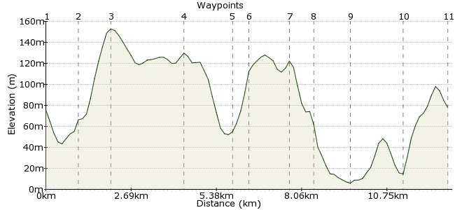
Elevation Profile


Ascent
231m (757ft)
Descent
228m (748ft)
Max. Elevation
160m (524ft)
Altitude Gain & Loss
459m (1505ft)
Start & End
Osmington
Distance
12.80km
(7.95mi)
(7.95mi)
Duration
~4:15h
Difficulty
Moderate
Ordnance Survey Map
This is a straightforward hill-and-coast combo in Dorset, a short bus ride from Weymouth. First stop is the Osmington White Horse, then a short ridge walk before dropping down to the coast, with a great pub near the end.
Walk Functions
Share
Nearby Walks
The South Dorset Ridgeway
A moderate, linear walk (countryside) starting in Dorset, England, about 19.40km (12.05 mi) long, duration: ~6:15h.The Portland Railway Walk
A moderate, linear walk (coast) starting in Dorset, England, about 10.50km (6.52 mi) long, duration: ~3:15h.Pottering around the Isle of Portland
A moderate, circular walk (coast) starting in Dorset, England, about 14.20km (8.82 mi) long, duration: ~4:15h.Walk Map
- $walk->POI array(0)
Waypoints
OS Grid SY723831
Take the bus to Osmington. Turn left and follow Church Lane past the church, heading gently uphill.
OS Grid SY721841
It gets a little steeper at the top as you leave the track and head for the top of the Dorset Downs.
About 1.02 km (~0.63 miles) from 

OS Grid SY712845
Turn west along the ridgeway path to reach the top of the hill. Perfect for breaking into the sandwiches with views of the sea.
About 1.00 km (~0.62 miles) from 

OS Grid SY734840
Retrace your steps and continue heading eastwards along the ridge, towards Foxwell Manor. The path goes uphill slightly before you reach the manor, dropping down to the road to the southeast.
About 2.24 km (~1.39 miles) from 

OS Grid SY745830
Cross the road and take the path directly opposite, which leads through a small patch of woodland.
About 1.49 km (~0.93 miles) from 

OS Grid SY748826
Turn left at the road and follow this for around 1km.
About 0.52 km (~0.32 miles) from 

OS Grid SY760822
Follow the track beyond the car park into the National Trust land. Continue towards the sea.
About 1.29 km (~0.8 miles) from 

OS Grid SY762816
Turn left at the footpath junction and head for Burning Cliff (don't worry, it's not really burning). Follow the coast path heading west.
About 0.63 km (~0.39 miles) from 

OS Grid SY750813
Pass through the village of Ringstead and follow the path.
About 1.20 km (~0.75 miles) from 

OS Grid SY735817
The walk towards Osmington Mills and the excellent Smugglers' Inn: http://smugglersinnosmingtonmills.co.uk. Beer with a sea view - what more could you want?
About 1.59 km (~0.99 miles) from 

OS Grid SY726828
There are no buses to Osmington Mills, so you need to return to Osmington via the bridleway that runs parallel to the road.
About 1.41 km (~0.88 miles) from 

 Osmington again