Huddersfield to Mirfield
A moderate walk (countryside) starting and finishing in Kirklees, England, about 11.20km (6.96 mi) long with an estimated walking time of about 3:30h. It is unsuitable for families with children, prams & pushchairs, wheelchairs.
Elevation Profile
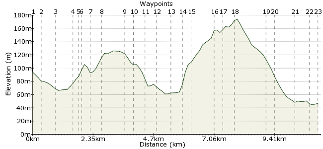
Ascent
157m (515ft)
Descent
205m (672ft)
Max. Elevation
180m (590ft)
Altitude Gain & Loss
362m (1187ft)
Start
Hudersfield railway station
End
Mirfield
Distance
11.20km
(6.96mi)
(6.96mi)
Duration
~3:30h
Difficulty
Moderate
Ordnance Survey Map
This is a weird (but enjoyable) walk in that it starts in Huddersfield town centre. It uses roads and passes housing, but has high-ridge routes overlooking the urbanised valley between Huddersfield & Mirfield from a sort of countryside-ish setting. Buses and trains to Huddersfield and Mirfield are incredibly frequent within the West Yorkshire area.
Walk Functions
Share
Nearby Walks
Huddersfield to Dewsbury
A moderate, linear walk (countryside) starting in West Yorkshire, England, about 13.30km (8.26 mi) long, duration: ~4:00h.Mirfield Circular
A moderate, walk (countryside) starting in Yorkshire and the Humber, England, about 10.60km (6.59 mi) long, duration: ~3:15h.Mirfield Circular over Dalton Bank
A leisurely, circular walk (countryside) starting in West Yorkshire, England, about 9.60km (5.97 mi) long, duration: ~3:00h.Walk Map
- $walk->POI array(0)
Waypoints
OS Grid SE143169
From the railway station head downhill passing The George Hotel on the left and continue into Northumberland Street to reach the road junction/traffic lights.
OS Grid SE146169
Turn right into Southgate. Cross the road at the pelican crossing and continue beyond the roundabout into Wakefield road to pass the canal basin.
About 0.34 km (~0.21 miles) from 
OS Grid SE149164
Continue following Wakefield Road as it crosses the River Colne and passes a number of small shops and just before the DW Fitness Club (on the right) turn left into Back Chapel Lane.
About 0.58 km (~0.36 miles) from 
OS Grid SE154162
After the second row of terraced houses turn right and follow the road uphill to the next junction.
About 0.56 km (~0.35 miles) from 
OS Grid SE156163
Turn left into Chapel Street briefly then turn left into Kilner Bank.
About 0.20 km (~0.12 miles) from 
OS Grid SE156163
Follow the road as it continues to rise the hill, and take a track/road on the right (Mount Zion Road) leading further uphill.
About 0.08 km (~0.05 miles) from 
OS Grid SE154166
Follow the track/road uphill to find a path on the left running through field in front of the housing and follow this.
About 0.31 km (~0.19 miles) from 
OS Grid SE154170
Beyond the housing reach an open area & head right, uphill to reach the cricket ground & a fine view across the valley. Follow a wide path into the woodland & continue along it to reach an open field.
About 0.40 km (~0.25 miles) from 
OS Grid SE160178
At he far end of the field turn right before the 5 bar gate to exit and pass the housing to reach Brown Royd Avenue & turn left.
About 0.98 km (~0.61 miles) from 
OS Grid SE162179
Follow the road ahead to reach the junction with Bradley Mills Road & turn right to shortly reach Netherhall Riding School on the left.
About 0.21 km (~0.13 miles) from 
OS Grid SE164176
Just beyond the riding school follow a path heading left, downhill, to the playground and follow through the park.
About 0.34 km (~0.21 miles) from 
OS Grid SE168173
Exit the park and follow the road left, then right and at the junction with Long Lane turn left. At a junction on the left follow Briggate/Nettleton Road to a mini-roundabout.
About 0.50 km (~0.31 miles) from 
OS Grid SE171175
Turn left and follow the road for 1/2 mile and turn right up Jagger Lane.
About 0.45 km (~0.28 miles) from 
OS Grid SE170179
Follow the lane to take a path on the left that rises uphill to climb Nab Hill.
About 0.40 km (~0.25 miles) from 
OS Grid SE172181
From the summit head north following the crest of the hill along Dalton Bank. You can take the lower or higher level, they both arrive at the same place beyond the old quarry.
About 0.29 km (~0.18 miles) from 
OS Grid SE174190
Beyond the old quarry follow the wall on the right to reach (and follow) a waymarked path on the right leading to Upper Heaton.
About 0.88 km (~0.55 miles) from 
OS Grid SE177191
Follow the path through the farm buildings to reach the road and turn right. Keep along the road (ignore a junction on the right) and turn left into North Moor Lane.
About 0.29 km (~0.18 miles) from 
OS Grid SE180188
Turn left into North Moor Lane and follow to reach the tarmac road, North Gate.
About 0.42 km (~0.26 miles) from 
OS Grid SE190192
Having turned left follow the road downhill. Ignore the waymarked path on the right at Crow Royd but take the path on the right a little further downhill that skirts north of Boyfe Hall.
About 1.16 km (~0.72 miles) from 
OS Grid SE192196
Once through the buildings you can either follow the RoW footpath following the wall on the right or head diagonally left across the field to join the bridleway track by the railway line.
About 0.38 km (~0.24 miles) from 
OS Grid SE200195
With either route you will turn left down Chadwick Lane/Calder Road and reach a junction. Turn right and follow the river on your left along Calder Road.
About 0.74 km (~0.46 miles) from 
OS Grid SE202191
At the junction by the Flower Pot pub (well it still is in 2015) turn left along Granny Lane and then left again to cross the river.& follow the road to the railway bridge.
About 0.48 km (~0.3 miles) from 
 Mirfield railway station
OS Grid SE204194
Access whichever platform you need to return to wherever.
About 0.39 km (~0.24 miles) from 
