Kirk Michael to St John's
A moderate walk (countryside) starting and finishing in , , about 12.00km (7.46 mi) long with an estimated walking time of about 3:30h. It is suitable for families with children, but unsuitable for prams & pushchairs, wheelchairs.
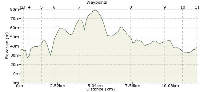
Elevation Profile


Ascent
50m (164ft)
Descent
47m (154ft)
Max. Elevation
80m (262ft)
Altitude Gain & Loss
97m (318ft)
Start
Kirk Michael
Distance
12.00km
(7.46mi)
(7.46mi)
Duration
~3:30h
Difficulty
Moderate
Ordnance Survey Map
 2Created by mac.hawk on 15 Feb 2015
A gentle amble along the disused railway line. Visits Kirk Michael (stone crosses) lovely Glen Mooar (with derelict chapel & wonderful waterfall) & St John's (Tynwald Hill & the fabulous arboretum). The walk's about 9 miles excluding what you wander in the arboretum. Buses No 5 & 6 hourly to/from Kirk Michael & St John's from Douglas/Peel/Ramsey. St John's has half hourly service to Douglas/Peel.
Walk Functions
Share
Nearby Walks
Snaelfell to Laxey 'off piste' in places!
A moderate, linear walk (low hills and fells (below 600m)) starting in , , about 11.90km (7.39 mi) long, duration: ~3:30h.Southern half of The Millennium Way
A moderate, linear walk (countryside) starting in Isle of Man, England, about 15.90km (9.88 mi) long, duration: ~4:45h.Laxey beach to Snaefell Summit
A moderate, linear walk (countryside) starting in Isle of Man, Isle of Man, about 9.80km (6.09 mi) long, duration: ~4:30h.Walk Map
- $walk->POI array(0)
Waypoints
OS Grid SC316907
Alight the bus at the stop adjacent the Methodist Church (both directions). A visit to the Parish Church a little further north reveals several Celtic\Christian crosses displayed inside the church.
OS Grid SC315906
Go back up the road and immediately beyond the IOM Bank turn right down Station Road for about 200 yards. You will meet the old railway line by the old station building. Turn left along the old track.
About 0.09 km (~0.06 miles) from 

OS Grid SC314907
Follow the bed of the former railway line to soon descend into Glen Wyllin (and the campsite).
About 0.17 km (~0.11 miles) from 

OS Grid SC312904
Don't turn right to follow the coastal path instead rise the steps ahead to rejoin the railway bed to shortly reach and cross the A4 road.
About 0.33 km (~0.21 miles) from 

OS Grid SC310897
After crossing the A4 road continue along the track bed to reach Glen Mooar. Here you need to descend the valley, cross the stream via the fotrbridge before rising to rejoin the rail track.
About 0.71 km (~0.44 miles) from 

OS Grid SC305892
However, after crossing the stream, detour left uphill along a wide path to pass a derelict Keeill then descend to view Spooyt Vane waterfall. Retrace steps back to the footbridge.
About 0.77 km (~0.48 miles) from 

OS Grid SC293881
Rejoin the rail track and follow for 1 mile to re-cross the A4 and contine along a section of Raad Ny Foillan.
About 1.63 km (~1.01 miles) from 

OS Grid SC270855
After 2 1/4 miles reach another of the old (converted) railway stations (St Germains) & the A4 road again. Directly cross the road and continue along the disused line.
About 3.47 km (~2.16 miles) from 

OS Grid SC264832
After 1 3/4 miles the track passes the A20 road.
About 2.29 km (~1.42 miles) from 

OS Grid SC268821
And after another 3/4 mile track crosses the A1 road shortly after which it joins the former track from Peel to St Johns.
About 1.17 km (~0.73 miles) from 

OS Grid SC276816
Upon reaching the road in St John's turn left to reach the main road junction where pub, cafe, convenience store, toilets, church & buses are available. The arboretum is beyond Tynwald Hill.
About 0.97 km (~0.6 miles) from 

 At John's