River Mersey Walk
A hard walk (riverside) starting and finishing in Merseyside, England, about 63.80km (39.64 mi) long with an estimated walking time of about 19:00h (2 overnight stays). It is unsuitable for families with children, prams & pushchairs, wheelchairs.
Elevation Profile
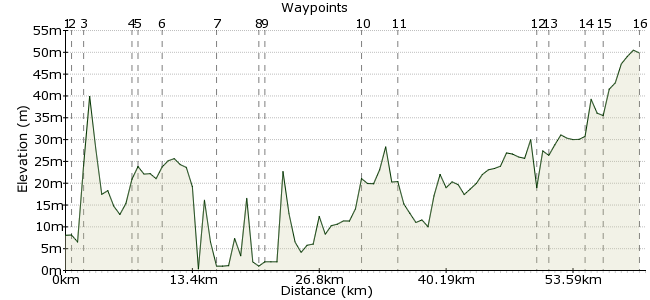
Ascent
79m (259ft)
Descent
38m (124ft)
Max. Elevation
60m (196ft)
Altitude Gain & Loss
117m (383ft)
Start
Pier Head, Liverpool
End
Stockport
Distance
63.80km
(39.64mi)
(39.64mi)
Duration
~19:00h
Difficulty
Hard
A 3 day walk of 50 miles along the River Mersey from Liverpool to Stockport. Some sections of the Mersey are inaccessible, so at these points the route follows either the Trans Pennine cycle route or the Bridgewater Canal.
If you use our guide to walking the Mersey please consider making a donation to Schools for Children of Cambodia at https://mydonate.bt.com/fundraisers/merseywalk.
Walk Functions
Share
Nearby Walks
Liverpool City Centre
A leisurely, circular walk (city/town) starting in Liverpool, England, about 6.80km (4.23 mi) long, duration: ~2:00h.Dream St.Helens
A leisurely, circular walk (woodland) starting in Merseyside, England, about 2.10km (1.30 mi) long, duration: ~0:30h.Holywell 2
A leisurely, circular walk (countryside) starting in Flintshire, Wales, about 8.40km (5.22 mi) long, duration: ~2:45h.Walk Map
- $walk->POI array(0)
Waypoints
OS Grid SJ339901
Home to Mersey Ferries, Liverpool’s famous river crossing. At Pier Head turn left and start walking past the ferry terminal on the promenade.
OS Grid SJ339898
2. Enter the Albert Dock and make your way over the swing bridge to the river wall to start this walk. Turn left - south - and walk down the river wall.
About 0.31 km (~0.19 miles) from 
OS Grid SJ347884
Continue south to Otterspool Promenade.
About 1.64 km (~1.02 miles) from 
OS Grid SJ388848
Otterspool promenade ends with a path leading inland to Grassendale Park.
About 5.45 km (~3.39 miles) from 
OS Grid SJ394848
You could walk this next section but its 3.5 miles along a dual carriageway. Friendly locals were happy to help us with directions and they all said get the 82 bus!
About 0.60 km (~0.37 miles) from 
OS Grid SJ417834
Leave the dual carriageway/get off the bus here and turn right onto Estuary Boulevard. Follow the Mersey Way past John Lennon Airport,
About 2.62 km (~1.63 miles) from 
OS Grid SJ471809
Walk east with the airport to you left and the river close on the right to Hale Head lighthouse, turn left going inland through Hale village in order to avoid Decoy Marsh.
About 6.00 km (~3.73 miles) from 
OS Grid SJ509835
Follow the Trans-Pennine Trail (Route 62) rejoining the river at Pickering’s Pasture for the stretch to the Runcorn–Widnes Bridge. Go under the bridge to reach Spike Island and its marina.
About 4.58 km (~2.85 miles) from 
OS Grid SJ514842
Follow the St Helens canal to Wilderspool.
About 0.89 km (~0.55 miles) from 
OS Grid SJ618867
Leave the canal, cross the Mersey and go under the railway bridge, follow Trans-Pennine Trail (62) to reach Wilderspool.
About 10.71 km (~6.65 miles) from 
OS Grid SJ652870
Walk east on the north bank of the canal to Sale Water Park to rejoin the Mersey.
About 3.38 km (~2.1 miles) from 
OS Grid SJ796933
Just past where the Mersey flows under the Bridgewater Canal, take the first crossing back to the Mersey. Do not cross the Mersey, turn left and continue on towards Stockport.
About 15.69 km (~9.75 miles) from 
OS Grid SJ806924
A historic pub situated on the banks of the River Mersey in Sale.
About 1.24 km (~0.77 miles) from 
OS Grid SJ841905
Fletcher Moss Park, Didsbury is named after local Alderman Fletcher Moss, who donated the park to the city of Manchester in 1917.
About 4.02 km (~2.5 miles) from 
OS Grid SJ855898
Here you need to leave the river for a short distance re-joining it after Waterside carpark. The river continues alongside the Mersey Vale Nature Park.
About 1.54 km (~0.96 miles) from 
OS Grid SJ895904
When you come up from the Mersey path, the Mersey Way shopping centre is in front of you. Go through the shopping centre to the far end and a wall surrounding a view of the Mersey passing underneath.
About 4.02 km (~2.5 miles) from 
 Source of the Mersey
OS Grid SJ898906
The source is marked by a wrought iron sculpture “Water is Life and Heaven’s Gift. Here Rivers Goyt and Tame become Mersey. Flowing Clear from Stockport to Seaâ€.
About 0.34 km (~0.21 miles) from 
