Cnicht and the Moelwyns from Nantgwynant
A moderate walk (mountain (above 600m)) in national park Snowdonia in Gwynedd, Wales, about 10.40km (6.46 mi) long with an estimated walking time of about 4:45h. It is unsuitable for families with children, prams & pushchairs, wheelchairs.
Elevation Profile
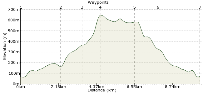
Ascent
569m (1866ft)
Descent
563m (1847ft)
Max. Elevation
650m (2132ft)
Altitude Gain & Loss
1132m (3713ft)
Start & End
Nantgwynant bus stop
Distance
10.40km
(6.46mi)
(6.46mi)
Duration
~4:45h
Difficulty
Moderate
Ordnance Survey Map
Cnicht, set in the heart of the Moelwyn hills, is a marked contrast to the busier peaks in Snowdonia - no artificial paths or summit cafes out here, just miles of boggy ground that can be a joy or a nightmare, depending on your outlook (and your boots).
This route starts and finishes in the Nantgwynant valley, served by the Snowdon Sherpa buses. There is a cafe nearby, more commonly used by people descending Snowdon's Watkin path, but equally welcome after a day in the bogs.
Walk Functions
Share
Nearby Walks
Snowdon's southern ridge
A moderate, circular walk (mountain (above 600m)) starting in Gwynedd, Wales, about 10.80km (6.71 mi) long, duration: ~5:45h.Llyn Dinas and Beddgelert
A leisurely, linear walk (riverside) starting in Gwynedd, Wales, about 8.40km (5.22 mi) long, duration: ~3:00h.Snowdon via Watkin Path
A moderate, linear walk (mountain (above 600m)) starting in Gwynedd, Wales, about 11.30km (7.02 mi) long, duration: ~6:00h.Walk Map
- $walk->POI array(0)
Waypoints
OS Grid SH628506
From the bus stop, take the footpath to Plas Gwynant. This soon joins a narrow lane, but it rarely sees much traffic. Keep on the road for 1.5km - there are options to take footpaths through some sections if you don't enjoy road walking.
OS Grid SH632484
Opposite the old quarry, take the footpath that heads to Gelli-lago and continue heading uphill alongside the stream.
About 2.23 km (~1.39 miles) from 
OS Grid SH638472
The path leaves the stream and heads between two rocky hills. Past the small lake, join the wall heading on to the southern end of Cnicht.
About 1.25 km (~0.78 miles) from 
OS Grid SH645466
From the wall, you can pick up the path leading to the summit of Cnicht. There's a little scramble just near the summit, but it looks worse from a distance - once in among the rocks there are plenty of good handholds.
About 0.99 km (~0.62 miles) from 
OS Grid SH657482
From the summit of Cnicht, head down the other side for a simple descent to Llyn yr Adar. Look for the footpath heading around the lake, which takes you back towards home.
About 2.00 km (~1.24 miles) from 
OS Grid SH646489
Where are the vowels?! At this point (ask a local for help with pronounciation), the path rejoins the country lane back to Nantgwynant.
About 1.36 km (~0.85 miles) from 
 Gwynant cafe
OS Grid SH626504
The Gwynant cafe offers a range of goodies to help restore the feeling in those squelchy toes. The bus stops are 100m along the road, heading towards Beddgelert or Pen y Pass.
About 2.38 km (~1.48 miles) from 
