The 'real' Snowdon horseshoe
A moderate walk (mountain (above 600m)) in national park Snowdonia in Gwynedd, Wales, about 10.20km (6.34 mi) long with an estimated walking time of about 5:30h. It is unsuitable for families with children, prams & pushchairs, wheelchairs.
Elevation Profile
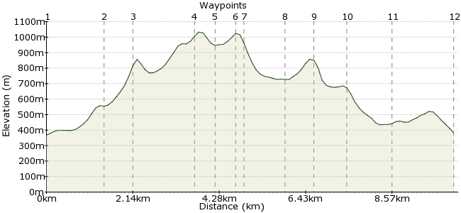
Ascent
854m (2801ft)
Descent
840m (2755ft)
Max. Elevation
1040m (3412ft)
Altitude Gain & Loss
1694m (5556ft)
Start & End
Pen y Pass
Distance
10.20km
(6.34mi)
(6.34mi)
Duration
~5:30h
Difficulty
Moderate
Ordnance Survey Map
There are many routes up and down Snowdon, each with their plusses and minuses. Many people opt for the classic ridge of Crib Goch as their preferred ascent, before racing down the Pyg Track or the Miners' Track back to Pen y Pass. While the way up can't be beaten - it's the UK's finest ridge outside Scotland - a better day out descends by the little used Lliwedd path, which keeps you up high to admire the views for as long as possible.
Walk Functions
Share
Nearby Walks
Snowdon from Pen-y-Pass to Llanberis
A moderate, linear walk (mountain (above 600m)) starting in Gwynedd, Wales, about 12.10km (7.52 mi) long, duration: ~5:15h.Snowdon via Miners' Track
A moderate, linear walk (mountain (above 600m)) starting in Gwynedd, Wales, about 11.20km (6.96 mi) long, duration: ~5:15h.The Glyders in a day - east to west
A moderate, linear walk (mountain (above 600m)) starting in Gwynedd, Wales, about 14.60km (9.07 mi) long, duration: ~6:15h.Walk Map
- $walk->POI array(0)
Waypoints
OS Grid SH647556
Pen y Pass is a regular stop on the Snowdon Sherpa bus. If you can see a route through the crowds of cars, rucksacks and bodies, make your way to the path signposted to Crib Goch (it heads to the right of the rocky outcrop just by the car park).
OS Grid SH633553
Last chance to back out...no? OK then, if the weather's fine and you're feeling fit, take the right-hand path that climbs steeply towards Crib Goch.
About 1.43 km (~0.89 miles) from 
OS Grid SH626553
For many people, the highlight of Snowdonia - a knife edge ridge scramble with sheer drops each side. There's nothing too tricky about the scramble in dry conditions, but don't underestimate it - go with someone experienced if you have not been scrambling before.
About 0.70 km (~0.43 miles) from 
OS Grid SH611552
Get your breath back on the slightly less imposing ridge up to Garnedd Ugain.
About 1.50 km (~0.93 miles) from 
OS Grid SH608548
Probably the busiest point in Britain's mountains, where four of the main routes up Snowdon converge. Anyone can find their way to the summit from here - just follow the crowds!
About 0.50 km (~0.31 miles) from 
OS Grid SH610544
The summit of Snowdon divides opinion - many revel in the satisfaction of climbing Wales' highest mountain, others detest the crowds and the cafe and can't get away quick enough.
About 0.45 km (~0.28 miles) from 
OS Grid SH611542
From the summit, it's not advisable to head straight on to the Lliwedd ridge - climbing down these rocks is notoriously tricky. A safer option is to drop down the southwestern ridge before soon joining the Watkin Path towards Bwlch Saethau.
About 0.23 km (~0.14 miles) from 
OS Grid SH619537
At this point, the Watkin Path drops into the valley. Instead, stay on the crest of the ridge. The path soon arrives at the West Peak of Y Lliwedd.
About 0.91 km (~0.57 miles) from 
OS Grid SH624532
Carry on over the summit and enjoy the space compared to the circus on Snowdon itself.
About 0.70 km (~0.43 miles) from 
OS Grid SH630535
The path drops down to Llyn Llydaw at the end of the cliff on Lliwedd's northeastern ridge. Carry on until the path meets the Miners' Track.
About 0.73 km (~0.45 miles) from 
OS Grid SH634545
Back amidst the hordes, but you can be smug in the knowledge you have enjoyed the finest horseshoe on Snowdon.
About 1.06 km (~0.66 miles) from 
 Back to Pen y Pass
OS Grid SH646554
Stay on the Miners' Motorway back to Pen y Pass, where your bus home awaits.
About 1.55 km (~0.96 miles) from 
