Mawddach Way
A hard walk (low hills and fells (below 600m)) in national park Snowdonia in Gwynedd, Wales, about 39.30km (24.42 mi) long with an estimated walking time of about 14:30h (1 overnight stay). It is unsuitable for families with children, prams & pushchairs, wheelchairs.
Elevation Profile
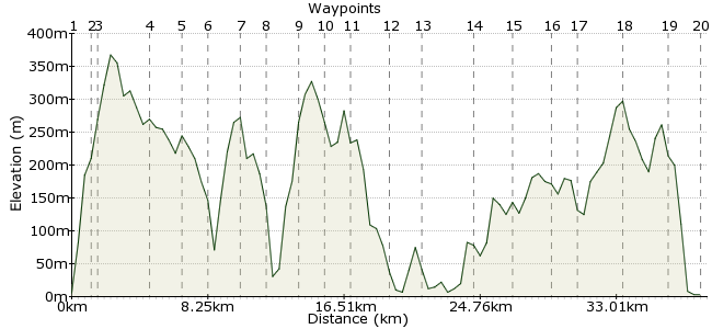
Ascent
1024m (3359ft)
Descent
1012m (3320ft)
Max. Elevation
370m (1213ft)
Altitude Gain & Loss
2036m (6679ft)
Start & End
Barmouth
Distance
39.30km
(24.42mi)
(24.42mi)
Duration
~14:30h
Difficulty
Hard
The Mawddach Way is a circular footpath walk around the Mawddach estuary, North Wales, covering almost 50 km and climbing a total of 2226 m along the way, before finishing with a crossing of the iconic Barmouth Bridge.
Detailed GPS data and a guide book are available from www.MawddachWay.co.uk
Walk Functions
Share
Nearby Walks
Panorama Walk
A leisurely, circular walk (low hills and fells (below 600m)) starting in Gwynedd, Wales, about 7.30km (4.54 mi) long, duration: ~3:00h.Cadair Idris the long way
A moderate, linear walk (mountain (above 600m)) starting in Gwynedd, Wales, about 15.50km (9.63 mi) long, duration: ~6:45h.Y Garn from Llanelltyd
A moderate, linear walk (mountain (above 600m)) starting in Gwynedd, Wales, about 10.70km (6.65 mi) long, duration: ~4:45h.Walk Map
- $walk->POI array(0)
Waypoints
OS Grid SH611158
Start of the walk
OS Grid SH618169
Old farm
About 1.30 km (~0.81 miles) from 
OS Grid SH620175
Pass
About 0.63 km (~0.39 miles) from 
OS Grid SH636200
Old roads cross
About 2.96 km (~1.84 miles) from 
OS Grid SH656201
Start of road
About 2.00 km (~1.24 miles) from 
OS Grid SH667190
Old Bridge
About 1.55 km (~0.96 miles) from 
OS Grid SH680206
Farm House
About 1.96 km (~1.22 miles) from 
OS Grid SH689191
Small Village
About 1.75 km (~1.09 miles) from 
OS Grid SH701202
Foel Ispri Hill top
About 1.62 km (~1.01 miles) from 
OS Grid SH713215
Road
About 1.77 km (~1.1 miles) from 
OS Grid SH726218
Farm House
About 1.33 km (~0.83 miles) from 
OS Grid SH717193
Old Bridge
About 2.65 km (~1.65 miles) from 
OS Grid SH728180
Dolgellau Town
About 1.70 km (~1.06 miles) from 
OS Grid SH694184
Penmaenpool
About 3.41 km (~2.12 miles) from 
OS Grid SH711169
Old Farm
About 2.26 km (~1.4 miles) from 
OS Grid SH697153
Farm
About 2.12 km (~1.32 miles) from 
OS Grid SH683160
Kings Youth Hostel
About 1.56 km (~0.97 miles) from 
OS Grid SH658145
Cregennen Lakes
About 2.91 km (~1.81 miles) from 
OS Grid SH637131
Farm
About 2.52 km (~1.57 miles) from 
 Barmouth Bridge
OS Grid SH623150
Toll Bridge
About 2.36 km (~1.47 miles) from 
