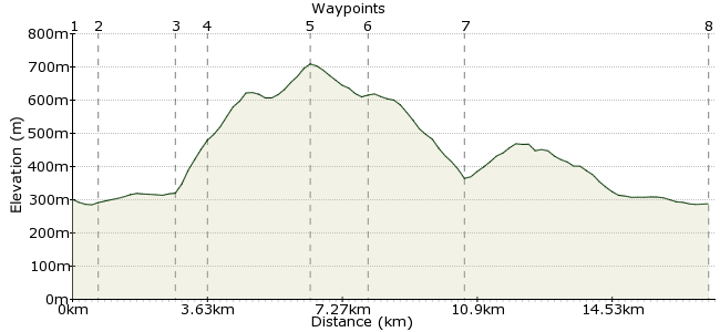
Stob na Cruaiche and Rannoch Moor
A moderate walk (moorland) in Highland, Scotland, about 17.30km (10.75 mi) long with an estimated walking time of about 6:15h. It is unsuitable for families with children, prams & pushchairs, wheelchairs.
Elevation Profile


Ascent
415m (1361ft)
Descent
428m (1404ft)
Max. Elevation
710m (2329ft)
Altitude Gain & Loss
843m (2765ft)
Start & End
Rannoch Station
Distance
17.30km
(10.75mi)
(10.75mi)
Duration
~6:15h
Difficulty
Moderate
Ordnance Survey Map
No wilderness left in Britain? You may think differently after this walk on the northern edge of Rannoch Moor. This 56 square miles of heather, peat and a lot of water - up to 95% in some places - is a forbidding place, especially when the mist rolls in. This walk gives you a chance to survey this vast expanse from the summit of Stob na Cruaiche, before returning via one of the few footpaths that dare cross the moor....
Walk Functions
Share
Nearby Walks
Rannoch to Fort William
A hard, walk (low hills and fells (below 600m)) starting in Perth and Kinross, Scotland, about 47.10km (29.27 mi) long, duration: ~15:00h.Corrour to Rannoch - a remote walk in Scotland
A strenuous, linear walk (mountain (above 600m)) starting in Highland, Scotland, about 25.70km (15.97 mi) long, duration: ~9:15h.Beinn na Lap and Loch Ossian
A moderate, walk (mountain (above 600m)) starting in Highland, Scotland, about 18.80km (11.68 mi) long, duration: ~8:00h.Walk Map
- $walk->POI array(0)
Waypoints
OS Grid NN423577
Start at Rannoch Station, one of the remotest outposts on the West Highland Railway. Despite the out of the way location, there is a hotel/pub and a great teashop on the station. During the deer stalking season, you should check at the pub if there are bits of the walk to avoid.
OS Grid NN416577
Take the footpath across the railway (signposted to Glencoe), and continue on past Cruach Cottage.
About 0.70 km (~0.43 miles) from 

OS Grid NN397568
The walk starts through forest, with only tantalising glimpses of Loch Laidon and the moor, but don't worry, it improves from here. Just before the path crosses Allt a' Bhuirich, there is a path leading steeply through the woods on the eastern side of the burn.
About 2.14 km (~1.33 miles) from 

OS Grid NN391572
From the edge of the forest, the track winds across the moor to the summit of Stob na Cruaiche. It's not marked on OS maps, but is easy to follow for the most part. Be aware, though, that it gets lost in the bogs at some points, so in bad weather you will need to use a map and compass as well.
About 0.72 km (~0.45 miles) from 

OS Grid NN363572
The high point of the A' Cruach hill is marked with a cairn. Fantastic views from here across to the hills of Glencoe to the west, and the expanse of Rannoch Moor and Loch Laidon to the south. Unbeatable.
About 2.79 km (~1.73 miles) from 

OS Grid NN347570
Stay on the shoulder of the ridge to Stob nan Losgann. From here, take a bearing south to hit the footpath between Rannoch and Glencoe (a continuation of the path you started on). It's heavy going underfoot, but the power lines will indicate how far left to go - they run alongside the path.
About 1.60 km (~0.99 miles) from 

OS Grid NN361549
The path is wet, boggy, uneven, and pretty tough going - but pretty much the only way to experience heading across Rannoch Moor! Keep heading east until the path enters the Creag Dhubh-bheag forest.
About 2.60 km (~1.62 miles) from 

OS Grid NN419578
In Rannoch, you have three options: catch the train home, head for a cup of tea in the cafe (which closes at 4.00, closed winter), or bed down for the night! No campsites, but wild camping on the estate is permitted if you ask first. Or go for a bit of comfort in the hotel: www.moorofrannoch.co.uk
About 6.51 km (~4.05 miles) from 

 Back to Rannoch