Streap from Glenfinnan
A moderate walk (mountain (above 600m)) in Highland, Scotland, about 18.00km (11.18 mi) long with an estimated walking time of about 7:30h. It is unsuitable for families with children, prams & pushchairs, wheelchairs.
Elevation Profile
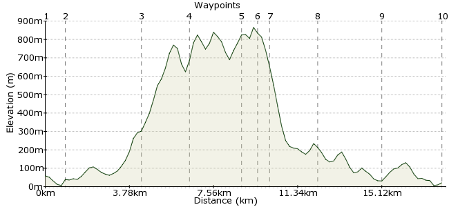
Ascent
781m (2562ft)
Descent
818m (2683ft)
Max. Elevation
870m (2854ft)
Altitude Gain & Loss
1599m (5245ft)
Start & End
Glenfinnan
Distance
18.00km
(11.18mi)
(11.18mi)
Duration
~7:30h
Difficulty
Moderate
Ordnance Survey Maps
Streap is one of many fine hills accessible from the West Highland Railway. It sits at the head of Glean Dubh Lighe, and the knife-edge ridge to the summit makes for a classic mountain adventure. Start and finish at Glenfinnan.
Walk Functions
Share
Nearby Walks
Glenfinnan to Inverie
A hard, linear walk (mountain (above 600m)) starting in Highlands, Scotland, about 39.60km (24.61 mi) long, duration: ~14:15h.Across Knoydart - Glenfinnan to Inverie
A hard, linear walk (low hills and fells (below 600m)) starting in Highlands, Scotland, about 39.90km (24.79 mi) long, duration: ~15:15h.Sgurr an Utha and Glenn Donn
A moderate, circular walk (mountain (above 600m)) starting in Highlands, Scotland, about 16.80km (10.44 mi) long, duration: ~7:15h.Walk Map
- $walk->POI array(0)
Waypoints
OS Grid NM898809
From the station, head back along the A830 for about 1km until you reach a forest track leading into Glean Dubh Lighe.
OS Grid NM907811
From the village, head under the viaduct and follow the track to Corryhully.
About 0.91 km (~0.57 miles) from 
OS Grid NM911844
The path leads to Corryhully bothy (handy if you want to do the Munros the next day). Cross the stream outside the bothy and head directly uphill, keeping left of the forest boundary.
About 3.31 km (~2.06 miles) from 
OS Grid NM932843
Head up the slope - no path - to Meall an Uillt Chaoil. From here, the route is clear, as well as the edgy nature of this walk - on a clear day, the sharp ridge up to the summit of Streap comes tantalisingly into view.
About 2.06 km (~1.28 miles) from 
OS Grid NM946861
The ridge becomes ever finer, and the drops ever more hairy as you approach the highest top of the day - Streap, a Corbett at 909m for those who like to tick these things off (like me).
About 2.31 km (~1.44 miles) from 
OS Grid NM947867
Drop down the northern shoulder of the mountain. This section has good views into the wilds of Knoydart.
About 0.61 km (~0.38 miles) from 
OS Grid NM943869
At around 400m of altitude (you will have to judge using your map skills!) contour round and join the clear path that runs along Gleann Cuirnean.
About 0.41 km (~0.25 miles) from 
OS Grid NM924857
The path rises over the lip of the valley between Streap and the Glenfinnan Munros, then follows the valley back to Corryhully.
About 2.17 km (~1.35 miles) from 
OS Grid NM906833
Once out of the glen, retrace your steps along the valley and under the viaduct to Glenfinnan.
About 2.98 km (~1.85 miles) from 
 Glenfinnan again
OS Grid NM902807
Back to Glenfinnan for the train home. A shame to finish with a bit of road walking, but well worth it for a mountain like Streap!
About 2.68 km (~1.67 miles) from 
