Sgor na h-Ulaidh in Glencoe
A moderate walk (mountain (above 600m)) in Highland, Scotland, about 17.20km (10.69 mi) long with an estimated walking time of about 7:45h. It is unsuitable for families with children, prams & pushchairs, wheelchairs.
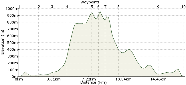
Elevation Profile


Ascent
940m (3083ft)
Descent
937m (3074ft)
Max. Elevation
960m (3149ft)
Altitude Gain & Loss
1877m (6157ft)
Start & End
Glencoe
Distance
17.20km
(10.69mi)
(10.69mi)
Duration
~7:45h
Difficulty
Moderate
Ordnance Survey Map
Glencoe is famous for its great mountain walks. Unfortunately buses only stop at Glencoe village and the ski centre, so it's not practical to do classics like the Aonach Eagach car-free without a long walk in. The best bet is the Munro of Sgor na h-Ulaidh, at the western end of the valley. The start of the walk is about 3km from the village, so plan a stay at nearby Glencoe Youth Hostel if possible to break up the walk. Buses between Glasgow and Fort William stop at Glencoe.
Walk Functions
Share
Nearby Walks
Glencoe to the Clachaig Inn
A moderate, circular walk (riverside) starting in Highlands, Scotland, about 10.10km (6.28 mi) long, duration: ~3:00h.The eastern Mamores
A moderate, circular walk (mountain (above 600m)) starting in Highlands, Scotland, about 13.40km (8.33 mi) long, duration: ~7:00h.A low-level walk along the lochs
A moderate, linear walk (low hills and fells (below 600m)) starting in Highlands, Scotland, about 21.00km (13.05 mi) long, duration: ~7:30h.Walk Map
- $walk->POI array(0)
Waypoints
OS Grid NN098587
Take the bus to Glencoe village, and enjoy the stunning scenery on the way. From Glencoe, head along the road through the village for the Youth Hostel (signposted). If you are going straight for the hills, follow the main road (A82) to Achnacon.
OS Grid NN117576
Another bonus of a night at the hostel is you can visit the Clachaig Inn, a mile along the road. For the walk, return towards the inn, and look for a path through the woods - this takes you to the footbridge across the river.
About 2.19 km (~1.36 miles) from 

OS Grid NN118563
Cross the A82 and head towards Achnacon. Just before the farm is a landrover track leading into Gleann Leac na Muidhe. This leads you in towards the big peaks.
About 1.30 km (~0.81 miles) from 

OS Grid NN118547
At the buildings in the valley, turn southeast on to the slopes of Aonach Dubh a' Ghlinne. Pick a line up the slope and press on!
About 1.55 km (~0.96 miles) from 

OS Grid NN118523
Follow the ridge to Stob na Fhuarain. It's not a Munro, despite being 968m at the cairn, as it's too close to the bigger peak nearby ...
About 2.44 km (~1.52 miles) from 

OS Grid NN112518
... which is Sgor na h-Ulaidh, another km or so along the ridge. Descending from here is the crux of the walk - head west towards Corr na Beinne before trying to descend. The northern slopes are not a good way down!
About 0.78 km (~0.48 miles) from 

OS Grid NN106514
Once at the lower summit of Corr na Beinne, pick a line down to Belach Easan. From here, the going is easy down to the burn.
About 0.67 km (~0.42 miles) from 

OS Grid NN107527
Follow the track on the eastern side of the burn, which takes you back to Achnacon (about 3-4 kms).
About 1.30 km (~0.81 miles) from 

OS Grid NN117566
At Achnacon, you can return to the hostel for the night, or press on along the road to Glencoe village for the bus.
About 4.01 km (~2.49 miles) from 

OS Grid NN100586
It's not all about the hills round here - an evening stroll around the shores of Loch Leven is a great way to finish your Glencoe adventure. Get the bus tomorrow and enjoy the wonderful scenery!
About 2.63 km (~1.63 miles) from 

 Glencoe village