Bromfield to Craven Arms
A moderate walk (countryside) starting and finishing in Shropshire, England, about 11.50km (7.15 mi) long with an estimated walking time of about 3:45h. It is suitable for families with children, but unsuitable for prams & pushchairs, wheelchairs.
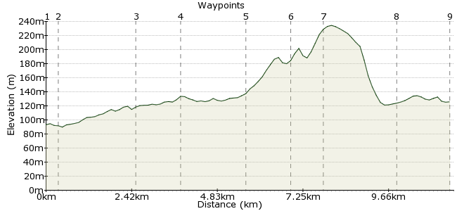
Elevation Profile


Ascent
140m (459ft)
Descent
107m (351ft)
Max. Elevation
240m (787ft)
Altitude Gain & Loss
247m (810ft)
Start
Bromfield
End
Craven Arms, Shropshire, England
Distance
11.50km
(7.15mi)
(7.15mi)
Duration
~3:45h
Difficulty
Moderate
Ordnance Survey Maps
This walk follows country paths through the beautiful countryside of Shropshire's Teme Valley. It's a lovely part of the country for which 'rolling' is the perfect description. Buses between Craven Arms and Ludlow stop at Bromfield.
This is one of several linear walks provided by Shropshire Walking. For more routes visit: www.shropshirewalking.co.uk/shropshire-way/linear-walks.htm
Walk Functions
Share
Nearby Walks
Overton to Ludlow
A leisurely, linear walk (woodland) starting in Shropshire, England, about 4.60km (2.86 mi) long, duration: ~1:15h.Richard's Castle to Orleton
A leisurely, linear walk (countryside) starting in Shropshire, England, about 6.20km (3.85 mi) long, duration: ~2:00h.From Orleton to Luston
A leisurely, linear walk (countryside) starting in Herefordshire, England, about 5.70km (3.54 mi) long, duration: ~1:30h.Walk Map
- $walk->POI array(0)
Waypoints
OS Grid SO480769
Take the bus to Bromfield. If coming from the north, cross the A49 via the underpass. Continue past the parish church.
OS Grid SO480766
At the bridge over the River Teme, take the footpath heading on the northern side of the river through the pasture.
About 0.34 km (~0.21 miles) from 

OS Grid SO458761
Head up to Stead Vallets farm.
About 2.20 km (~1.37 miles) from 

OS Grid SO446766
Walk to the road heading to Duxmoor. To avoid the road walk, you can take a longer loop round via Cookeridge.
About 1.30 km (~0.81 miles) from 

OS Grid SO444784
Head up to the quiet village of Whittytree. Take the path across the road heading uphill.
About 1.80 km (~1.12 miles) from 

OS Grid SO432787
Follow the path then loop back to join the bridleway into Aldon Gutter.
About 1.30 km (~0.81 miles) from 

OS Grid SO434795
Head into Aldon and follow the road uphill, which has amazing views over the Onny valley.
About 0.84 km (~0.52 miles) from 

OS Grid SO435815
Cross the Marches railway line, with wonderful views of Stokesay Castle and Norton Wood.
About 1.99 km (~1.24 miles) from 

OS Grid SO427829
Follow the Shropshire Way into Craven Arms to complete the walk.
About 1.60 km (~0.99 miles) from 

 Craven Arms