A Plan B in the Cairngorms
A moderate walk (mountain (above 600m)) in national park Cairngorms starting and finishing in Highlands, Scotland, about 13.80km (8.57 mi) long with an estimated walking time of about 5:30h. It is unsuitable for families with children, prams & pushchairs, wheelchairs.
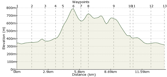
Elevation Profile


Ascent
538m (1765ft)
Descent
562m (1843ft)
Max. Elevation
790m (2591ft)
Altitude Gain & Loss
1100m (3608ft)
Start
South of Glenmore
End
Loch Morlich Watersports, Aviemore, Inverness-Shire, Scotlan
Distance
13.80km
(8.57mi)
(8.57mi)
Duration
~5:30h
Difficulty
Moderate
Ordnance Survey Map
 Car Free Walks TeamCreated by GaryShipp on 04 Feb 2012
This is a great route for those who prefer a less challenging / exposed walk in the Cairngorms, or for when the weather on the plateau is too inhospitable. It offers fine views and varied scenery, taking in several small summits and some preserved Scots pine forests.Â
Walk Functions
Share
Nearby Walks
Eagle Corrie from Glenmore
A moderate, circular walk (low hills and fells (below 600m)) starting in Highlands, Scotland, about 13.20km (8.20 mi) long, duration: ~4:45h.Bynack More and Barns of Bynack
A moderate, circular walk (mountain (above 600m)) starting in Highland, Scotland, about 19.80km (12.30 mi) long, duration: ~7:45h.Braeriach
A strenuous, circular walk (mountain (above 600m)) starting in Highlands, Scotland, about 20.00km (12.43 mi) long, duration: ~8:30h.Walk Map
- $walk->POI array(0)
Waypoints
OS Grid NH981088
Alight the Aviemore to Cairngorm bus at the entrance to the car park - you will have to speak to the driver to arrange.
OS Grid NH991097
Turn right along the main track.
About 1.36 km (~0.85 miles) from 

OS Grid NJ000106
Beautiful little almost emerald coloured Lochan.
About 1.24 km (~0.77 miles) from 

OS Grid NJ005114
This easy to access bothy offers a place to shelter in poor weather or an overnight stay.
About 0.98 km (~0.61 miles) from 

OS Grid NH999113
Take the time to read the information finger posts on the way up the hill for some interesting facts about the wildlife and fauna of this area.
About 0.55 km (~0.34 miles) from 

OS Grid NH990115
810 metres high at the summit affords stunning views in all directions.
About 0.97 km (~0.6 miles) from 

OS Grid NH984116
As the main path leaves back to Glenmore Village, the path gets less maintained and boggy down here.
About 0.63 km (~0.39 miles) from 

OS Grid NH978120
Another spot with excellent views.
About 0.70 km (~0.43 miles) from 

OS Grid NH961136
Take in the final views before heading SSW towards the forestry area.
About 2.36 km (~1.47 miles) from 

OS Grid NH949130
Look out for the orange waymark arrows and follows these into the forest.
About 1.32 km (~0.82 miles) from 

OS Grid NH947129
Turn tight at the junction and keep heading straight on the main track. The orange waymarkers should help you feel you're on the right track.
About 0.21 km (~0.13 miles) from 

OS Grid NH955115
Head through the buildings and then down the entrance drive. It is possible to arrange camping or accommodation here at certain times of the year.
About 1.65 km (~1.03 miles) from 

OS Grid NH950103
Running parallel to the road there is cycle / walking track signposted the 'Old Logging Track'.
About 1.29 km (~0.8 miles) from 

 Old Logging Track
2 comments... join the discussion!
patrikG
Hi Pete, indeed, it's by the man himself.
driver 16
Is this by the Gary of carfreewalks ?