Foel Penolau
A moderate walk (mountain (above 600m)) in national park Snowdonia in Gwynedd, Wales, about 12.80km (7.95 mi) long with an estimated walking time of about 5:00h. It is unsuitable for families with children, prams & pushchairs, wheelchairs.
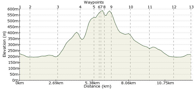
Elevation Profile


Ascent
452m (1482ft)
Descent
458m (1502ft)
Max. Elevation
590m (1935ft)
Altitude Gain & Loss
910m (2984ft)
Start & End
Trawsfynydd
Distance
12.80km
(7.95mi)
(7.95mi)
Duration
~5:00h
Difficulty
Moderate
Ordnance Survey Map
This summit is a modest height, but the approach demands respect. The rocky cliffs around the summit of Foel Penolau, at the northern end of the Rhinog mountains, make for some great scrambling, but it can be tricky to find the way up. Save this walk for a clear, dry day when you can enjoy the intracacies of this fine mountain.
Walk Functions
Share
Nearby Walks
Tan y Bwlch to Blaneau Ffestiniog
A leisurely, linear walk (woodland) starting in Gwynedd, Wales, about 7.40km (4.60 mi) long, duration: ~2:15h.The Rhinog ridge
A strenuous, linear walk (mountain (above 600m)) starting in Gwynedd, Wales, about 25.40km (15.78 mi) long, duration: ~10:00h.Blaenau Ffestiniong
A leisurely, circular walk (countryside) starting in Clwyd, Wales, about 6.00km (3.73 mi) long, duration: ~2:00h.Walk Map
- $walk->POI array(0)
Waypoints
OS Grid SH706355
Take the bus to Trawsfynydd. Walk to the edge of the reservoir and head for the footbridge.
OS Grid SH701348
Once across, turn right and follow the road along the edge of the reservoir.
About 0.89 km (~0.55 miles) from 

OS Grid SH684358
At Tyn Twll farm, take the footpath heading into the hills.
About 1.96 km (~1.22 miles) from 

OS Grid SH668357
Leave the path and head to the level ground at Cwm Moch.
About 1.61 km (~1 miles) from 

OS Grid SH660351
The rock walls look impenetrable, but if you follow the base to the western edge, there is a scrambly route up onto Diffys.
About 0.93 km (~0.58 miles) from 

OS Grid SH662349
From here, it's another scramble up onto the summit.
About 0.30 km (~0.19 miles) from 

OS Grid SH661348
Reach the top for superb views all around.
About 0.17 km (~0.11 miles) from 

OS Grid SH659349
Climb down carefully the way you came - there are few other routes off, so take care - and continue round the base of the summit to the saddle between Foel Penolau and Moel Ysgyfarnagod.
About 0.27 km (~0.17 miles) from 

OS Grid SH660346
From the saddle, pick your way beneath the rocky cliffs of Foel Penolau.
About 0.37 km (~0.23 miles) from 

OS Grid SH673342
Pick up the track in the valley east of the mountains.
About 1.34 km (~0.83 miles) from 

OS Grid SH686335
The track joins the road and heads past Ty-cerrig to the reservoir.
About 1.43 km (~0.89 miles) from 

OS Grid SH696347
At Tyndrain, turn right back to the footbridge.
About 1.61 km (~1 miles) from 

OS Grid SH708354
Return to the town for the bus home.
About 1.33 km (~0.83 miles) from 

 Trawsfynydd again