Exton to Topsham - an Avocet Amble
A leisurely walk (countryside) starting and finishing in Devon, England, about 8.80km (5.47 mi) long with an estimated walking time of about 2:30h. It is suitable for families with children, but unsuitable for prams & pushchairs, wheelchairs.
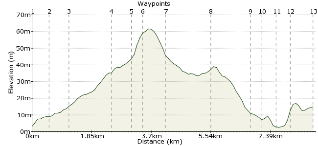
Elevation Profile


Ascent
68m (223ft)
Descent
56m (183ft)
Max. Elevation
70m (229ft)
Altitude Gain & Loss
124m (406ft)
Start
Exton
End
Topsham
Distance
8.80km
(5.47mi)
(5.47mi)
Duration
~2:30h
Difficulty
Leisurely
Ordnance Survey Maps
This walk starts and finishes at stations on the Avocet Line, which runs from Exeter to Exmouth. It's a gentle wander from Exton to Woodbury, then via an RSPB reserve to Topsham. There are good views across the Exe Estuary for parts of the walk.
More walks on this line are available here (look for the link to download a PDF): www.avocetline.org.uk/places-to-go-and-things-to-do/walking-cycling-and-ferries/
Walk Functions
Share
Nearby Walks
Exmouth town walk
A leisurely, circular walk (city/town) starting in Devon, England, about 5.70km (3.54 mi) long, duration: ~1:30h.Exmouth to Sidmouth
A moderate, linear walk (coast) starting in Devon, England, about 19.20km (11.93 mi) long, duration: ~6:00h.The Jurassic Coast from Sidmouth to Seaton
A moderate, linear walk (coast) starting in Devon, England, about 14.00km (8.70 mi) long, duration: ~5:00h.Walk Map
- $walk->POI array(0)
Waypoints
OS Grid SX980863
Start at Exton station. Walk up Station Road past the Puffing Billy pub.
OS Grid SX986864
Cross the main road and join Rydon Lane. Look for the footpath on the right-hand side.
About 0.58 km (~0.36 miles) from 

OS Grid SX991866
Cross the footbridge and follow the path alongside the brook.
About 0.51 km (~0.32 miles) from 

OS Grid SY003868
The path leads to a lane on the edge of Woodbury.
About 1.24 km (~0.77 miles) from 

OS Grid SY008870
This is a delightful little village and worth pottering about in for a short while.
About 0.56 km (~0.35 miles) from 

OS Grid SY008873
Go past the church and turn left into Oakhayes Road.
About 0.32 km (~0.2 miles) from 

OS Grid SY002871
At Shepherds Park Farm, turn right and follow the lane into Ebford.
About 0.66 km (~0.41 miles) from 

OS Grid SX992880
Turn left here to continue into Ebford.
About 1.31 km (~0.81 miles) from 

OS Grid SX980879
Follow Lower Lane into the village of Ebford and turn right at the end.
About 1.16 km (~0.72 miles) from 

OS Grid SX976879
Take the path opposite, passing by Greenvalley Nursery. Turn left when you reach the river.
About 0.39 km (~0.24 miles) from 

OS Grid SX975876
Cross over via the railway bridge. There are viewpoints cut into the fence to allow you to peek into the RSPB reserve: www.rspb.org.uk/discoverandenjoynature/seenature/reserves/guide/b/bowlinggreenmarsh
About 0.31 km (~0.19 miles) from 

OS Grid SX971878
Continue alongside the railway line into Topsham. You will need to go under the bridge at the edge of the village to join Bowling Green Lane.
About 0.47 km (~0.29 miles) from 

OS Grid SX966884
Cross back over the railway via the bridge to follow Elm Grove Road to the station.
About 0.69 km (~0.43 miles) from 

 Elm Grove Road