The Ingleton Waterfall Walk
A leisurely walk (riverside) in national park Yorkshire Dales in West Yorkshire, England, about 5.30km (3.29 mi) long with an estimated walking time of about 1:45h. It is suitable for families with children, but unsuitable for prams & pushchairs, wheelchairs.
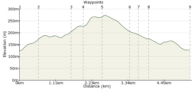
Elevation Profile


Ascent
152m (498ft)
Descent
149m (488ft)
Max. Elevation
280m (918ft)
Altitude Gain & Loss
301m (986ft)
Start & End
Ingleton
Distance
5.30km
(3.29mi)
(3.29mi)
Duration
~1:45h
Difficulty
Leisurely
Ordnance Survey Map
The is a Yorkshire Dales classic - a family-friendly walk that visits 10 waterfalls, each hidden in the gently rolling countryside around Ingleton. The only downside is that there is a charge for the walk - pretty cheeky I think, but worth it if you are feeling flush.
Ingleton can easily be reached by bus, including the Dalesbus (www.dalesbus.org). There are good services from Lancaster and Settle, plus less regular services from most of the major towns around these parts.
Walk Functions
Share
Nearby Walks
High Bentham to Settle - South & East
A strenuous, linear walk (low hills and fells (below 600m)) starting in North Yorkshire, England, about 26.40km (16.40 mi) long, duration: ~8:45h.High Bentham to Ribblehead
A moderate, linear walk (mountain (above 600m)) starting in North Yorkshire, England, about 17.20km (10.69 mi) long, duration: ~7:00h.Tour of Ingleborough
A hard, circular walk (mountain (above 600m)) starting in North Yorkshire, England, about 40.00km (24.85 mi) long, duration: ~13:15h.Walk Map
- $walk->POI array(0)
Waypoints
OS Grid SD695734
Ingleton is a great little village - look out for the Ye Olde Village Sweet Shop, with its old-fashioned jars of classic treats. Or head to Bernie's Cafe if you need some hot grub. The waterfalls walk is well signposted throughout the village.
OS Grid SD694739
The path follows the River Twiss to start with, quickly taking you to the first waterfall, Swilla Glen. The route passes through woodland on this section, with a good diversity of wild flowers.
About 0.57 km (~0.35 miles) from 

OS Grid SD695749
There are two separate waterfalls in quick succession here - First Pecca Falls and Pecca Twin Falls. As the route rises out of the valley, the woodland gives way to heathland.
About 0.95 km (~0.59 miles) from 

OS Grid SD694752
The path gets steeper as it leads up to Hollybush Spout, but there is a cafe here if you need sustenance. Carry on to Thornton Force, the largest waterfall on the route.
About 0.38 km (~0.24 miles) from 

OS Grid SD700752
The footpath leaves the Twiss and crosses the farmland at the foot of Twisleton Scar End, the craggy southern tip of Whernside - one of the Yorkshire Dales' Three Peaks.
About 0.58 km (~0.36 miles) from 

OS Grid SD705747
The route becomes a riverside walk once more, but this time it's the River Doe. The first waterfall on this section is Beezley Falls, with three separate falls running side by side.
About 0.72 km (~0.45 miles) from 

OS Grid SD704744
Next are Rival Falls, where the path looks down on the water from a great height. Carry on through Baxenghyll Gorge, where there is a bridge that spans the river - great for a photo of the water crashing through the gorge!
About 0.29 km (~0.18 miles) from 

OS Grid SD702742
The last waterfall of the day is Snow Falls, which flows out of the end of the gorge. Carry on along the riverside path into Ingleton. Look out for the old quarries just off the path.
About 0.21 km (~0.13 miles) from 

OS Grid SD695732
Back into Ingleton for some more sweets or a drink, and the bus home.
About 1.26 km (~0.78 miles) from 

 Ingleton again
6 comments... join the discussion!
mac.hawk
There is now a turnstile at the entrance to the walk following the River Twiss (Peccs Falls). Parking is free but entrance to the walk at this point is £7 (under 16's £3) per person. It is still possible to walk the route for free if your start/return point is at the River Doe (Beezley Falls) end of the trail.
Did the walk recently with my 4 year old Grandaughter and she loved every minute of it.
mac.hawk
Perfectly walkable from the railway station in High Bentham if you're prepared to make the effort, adds about 8 miles to the route, but easily do-able in a day if the rail service suits you. Do they charge you if you're on foot - I've seen somewhere (I can't remember where) that a hiker on foot was approached to pay but ignored the challenge and continued along the trail without hassle.
Timwoods
Hi Chris I think you've missed the point of our website – we suggest you go by bus, not by car! But charging people to get in does seem a bit much, granted. Tim
chris
They charge you to park, and charge you per PERSON not per car! £6 per person, absolute rip off. Better places to walk that aren't a con.
patrikG
Spot on, Mac. I've changed the walk so it now shows up under "suitable for families".
mac.hawk
I'd have thought this is eminently suitable for families with children about 8+. The walk is more like 4 1/2 miles and there are quite a few steps along the way (mostly up the Pecca & down the Beezley), there is also invariably an ice-cream van (tea, coffee & cold drinks too) sat on the track below Twisleton Scar End (about where it shows 285 map height on the OS map) from (at least) spring to late autumn. The charge is because the route is predominatly on privately owned land.