Rambles from the Bittern & Wherry Lines in Norfolk
A leisurely walk (countryside) in national park Norfolk Broads in Norfolk, England, about 3.30km (2.05 mi) long with an estimated walking time of about 1:00h. It is unsuitable for families with children, prams & pushchairs, wheelchairs.
Elevation Profile
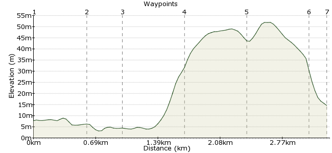
Ascent
39m (127ft)
Descent
32m (104ft)
Max. Elevation
60m (196ft)
Altitude Gain & Loss
71m (231ft)
Start & End
Stations between Norwich and Great Yarmouth & Sheringham
Distance
3.30km
(2.05mi)
(2.05mi)
Duration
~1:00h
Difficulty
Leisurely
Ordnance Survey Map
This is not just one car-free route; it's a pointer to a whole range of routes! There are great walks from each railway station between Norwich, Cromer, Sheringham, Great Yarmouth and Lowestoft. Visit these websites to access the routes:
www.bitternline.com/walks2.htm and www.wherrylines.org.uk/walks.htm
As a taster, here is a walk exploring Norwich's hidden wildlife, stopping at Ketts Hill, Lion Wood and Rosary Corner.
Walk Functions
Share
Nearby Walks
Aylsham and the Blickling Estate
A leisurely, walk (countryside) starting in Norfolk, England, about 8.80km (5.47 mi) long, duration: ~2:30h.The Wherryman's Way from Berney Arms to Great Yarmouth
A leisurely, linear walk (riverside) starting in Norfolk, England, about 8.40km (5.22 mi) long, duration: ~2:15h.Boudicca Way
A hard, linear walk (countryside) starting in Norfolk, England, about 40.20km (24.98 mi) long, duration: ~12:00h.Walk Map
- $walk->POI array(0)
Waypoints
OS Grid TG238083
All the Wherry and Bittern Line walks start and finish at stations with connections to Norwich - visit the weblinks for more details of each route. For the walk around Norwich itself, cross Foundry Bridge. Turn into the pub garden for a riverside walk.
OS Grid TG239089
From Bishopgate, follow the river round to Whitefriars Bridge. From here, turn left towards the cathedral. Along the river, you may spot kingfishers, great crested grebes or grey wagtails.
About 0.59 km (~0.37 miles) from 
OS Grid TG236089
Once you have seen the cathedral, return to Bishopgate and cross the river again.
About 0.37 km (~0.23 miles) from 
OS Grid TG242091
At the roundabout, head up Ketts Hill. Halfway up is the entrance to Ketts Heights. There are plenty of wildflowers here, which in turn attract many butterflies. You may also spot blackcaps or willow warblers.
About 0.65 km (~0.4 miles) from 
OS Grid TG248087
Continue up the hill to Lion Wood, an ancient woodland containing beech and oak, holly and hornbeam, with Norway maple, horse chestnut and sycamore. Keep an eye put for woodpeckers and nuthatches.
About 0.69 km (~0.43 miles) from 
OS Grid TG241088
Head down Telegraph Lane East to Rosary Cemetery, where you will see many wildflowers - it's managed to allow them to grow around the gravestones - and maybe even the odd tawny owl.
About 0.65 km (~0.4 miles) from 
 Back to the station
OS Grid TG240086
Head back to the station via Rosary Road, which joins Thorpe Road.
About 0.19 km (~0.12 miles) from 
