Llandudno, Llanrhos and Deganwy-Llandudno
A moderate walk (coast) in Clwyd, Wales, about 12.40km (7.71 mi) long with an estimated walking time of about 4:15h. It is suitable for families with children, but unsuitable for prams & pushchairs, wheelchairs.
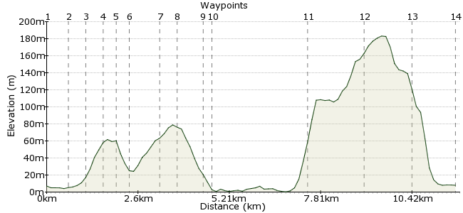
Elevation Profile


Ascent
263m (862ft)
Descent
262m (859ft)
Max. Elevation
190m (623ft)
Altitude Gain & Loss
525m (1721ft)
Start & End
Llandudno
Distance
12.40km
(7.71mi)
(7.71mi)
Duration
~4:15h
Difficulty
Moderate
Ordnance Survey Map
 1Created by driver 16 on 02 Sep 2012
This walk was promoted by Mostyn Art Gallery (www.mostyn.org), 'Artist Walking with Alison Lloyd', and shows the connection between the art of conversation within the group, the art of reading a picture (i.e. the map in hand), making your own pictures (i.e. taking photographs), and quoting authors who have written about the countryside in poems and books. It was very enlightening.
Walk Functions
Share
Nearby Walks
Great Orme, Llandudno
A leisurely, circular walk (city/town) starting in Clwyd, Wales, about 4.50km (2.80 mi) long, duration: ~1:45h.Llandudno-Conway RSPB reserve
A leisurely, linear walk (riverside) starting in Clwyd, Wales, about 7.20km (4.47 mi) long, duration: ~2:00h.Little Orme to Penrhynside
A leisurely, circular walk (countryside) starting in Clwyd, Wales, about 4.70km (2.92 mi) long, duration: ~1:30h.Walk Map
- $walk->POI array(0)
Waypoints
OS Grid SH783819
Ahead is a wood carving by Alice (see walk 'Colwyn Bay to Llandudno' at flickr). Turn right between the car wash and hairdressers into Oxford Road, then first right into Builder Street. Next, take the first left into Cwm Road, then straight on past Junior Welsh School and Secondary School to meet Maesdu Road, waypoint 2.
OS Grid SH785813
Cross at the pelican crossing, turn right then left into Bodnant Road, and straight up over the first mini roundabout. Continue to the second mini roundabout, bear left, and look for a footpath sign between the houses on the right, waypoint 3.
About 0.64 km (~0.4 miles) from 

OS Grid SH788809
A steady climb past the old quarry on the right to the top of Cwm Mountain, waypoint 4.
About 0.55 km (~0.34 miles) from 

OS Grid SH785805
There are views over to Folly at Bodysgallen National Trust Hotel and the Conway Valley and over to where you are heading - Deganwy Castle. Continue on well marked paths and over stiles.
About 0.45 km (~0.28 miles) from 

OS Grid SH784803
Follow the path around the back of a farm, to an old estate wall, along an overgrown path. Continue over a stile into a field, and down to Bryn Gosol Road.
About 0.23 km (~0.14 miles) from 

OS Grid SH781805
Head straight up the road; cross at the first junction, and take the second left into Arfryn up to waypoint 7.
About 0.42 km (~0.26 miles) from 

OS Grid SH784798
On the right, look for a footpath sign between the houses. Head for two lumps of hills with a tower on them.
About 0.77 km (~0.48 miles) from 

OS Grid SH784792
Cross the stile in front and to the right. Deganwy Castle is not really a castle; more just a watch tower. Go between the two mounds, and follow the path down to Gannock Park and down to main road.
About 0.54 km (~0.34 miles) from 

OS Grid SH777792
There is a footpath sign directly opposite; take care crossing, there is a blind bend. Walk across the bridge over the railway, then through terraced houses to the beach, waypoint 10.
About 0.71 km (~0.44 miles) from 

OS Grid SH776793
Turn right and follow the path to West Shore in Llandudno, waypoint 11.
About 0.14 km (~0.09 miles) from 

OS Grid SH770821
Carry on past the boating lake, past new flats, and past the building site of the old Gogarth Abbey, reputedly where, Lewis Carroll wrote 'Alice in Wonderland'. Take the path on the right, known as 'Invalids Walk'.
About 2.84 km (~1.76 miles) from 

OS Grid SH759833
A straightforward walk into Halfre Gardens, waypoint 13.
About 1.65 km (~1.03 miles) from 

OS Grid SH772830
Head downhill, then straight across into Wellington Road. Keep going straight across Gloddaeth Avenue, across Lloyd Street, across Trinity Avenue, and on to the station - the end of the walk.
About 1.37 km (~0.85 miles) from 

OS Grid SH783821
End of the walk; once again, I hope you enjoyed it.
About 1.33 km (~0.83 miles) from 

 Station