An arable amble in Suffolk
A leisurely walk (countryside) in Suffolk, England, about 7.70km (4.78 mi) long with an estimated walking time of about 2:15h. It is suitable for families with children, but unsuitable for prams & pushchairs, wheelchairs.
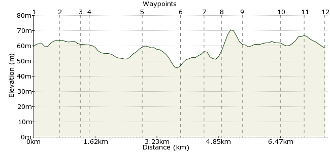
Elevation Profile


Ascent
22m (72ft)
Descent
23m (75ft)
Max. Elevation
80m (262ft)
Altitude Gain & Loss
45m (147ft)
Start & End
Otley
Distance
7.70km
(4.78mi)
(4.78mi)
Duration
~2:15h
Difficulty
Leisurely
Ordnance Survey Map
Car Free Walks doesn't have a no-frills option, but this walk would surely tick it. Nothing flash, no real points of interest, just random paths around farmland typical of Suffolk. I only discovered it as my dad lives in Otley, but it's the perfect "breath of fresh air" just 20 minutes by bus from Ipswich.
Walk Functions
Share
Nearby Walks
Helmingham deer park
A leisurely, circular walk (countryside) starting in Suffolk, England, about 4.00km (2.49 mi) long, duration: ~1:00h.Walking south through Suffolk
A moderate, linear walk (countryside) starting in Suffolk, England, about 11.10km (6.90 mi) long, duration: ~3:15h.Martlesham Creek and the River Deben
A leisurely, circular walk (riverside) starting in Suffolk, England, about 5.10km (3.17 mi) long, duration: ~1:30h.Walk Map
- $walk->POI array(0)
Waypoints
OS Grid TM202552
Start in Otley village. There is an excellent village shop opposite the bus stop if you need a little something for the walk.
OS Grid TM207557
Follow Chapel Road past the school on the left. Beyond this, take Hall Lane towards Otley Hall.
About 0.66 km (~0.41 miles) from 

OS Grid TM204562
Before you reach the hall, take the path on the left-hand side across the fields. There is a moat marked on the maps; aim for this (although not actually much to see).
About 0.56 km (~0.35 miles) from 

OS Grid TM202562
The walk tests your navigation skills in recognising field boundaries; interesting if you like that sort of thing (like I do). Note that some paths around here have been diverted; follow the signs rather than the map. Most paths are well maintained too, so easy to spot/follow.
About 0.20 km (~0.12 miles) from 

OS Grid TM202575
A long stretch heading north takes you through arable fields marked out by hedgerows. You'll hear a lot of birdlife in the hedges; aren't they wonderful things. Near Bastings Hall, take the path heading west towards Helmingham.
About 1.34 km (~0.83 miles) from 

OS Grid TM192575
Short stretch of road walking through Helmingham. Turn left at the junction by the church.
About 0.96 km (~0.6 miles) from 

OS Grid TM188571
Just beyond Helmingham Park is a footpath; look for the stile hidden behind the bus stop.
About 0.55 km (~0.34 miles) from 

OS Grid TM192569
Sadly you can't go through Round Wood; it's a nature reserve so leave those animals in peace. No paths marked, but there is a track around the northern edge, connecting the path on the southern side.
About 0.41 km (~0.25 miles) from 

OS Grid TM192565
Beneath the woods, the footpath crosses more arable land towards Otley.
About 0.46 km (~0.29 miles) from 

OS Grid TM196556
The footpath splits; take the left-hand path towards Otley.
About 0.95 km (~0.59 miles) from 

OS Grid TM202557
A quick stop at the village pub if you're thirsty.
About 0.56 km (~0.35 miles) from 

OS Grid TM204552
Back to Otley for the bus home.
About 0.59 km (~0.37 miles) from 

 Otley again