Plynlimon in the Cambrian Mountains
A moderate walk (mountain (above 600m)) in Ceredigion, Wales, about 18.50km (11.50 mi) long with an estimated walking time of about 7:00h. It is unsuitable for families with children, prams & pushchairs, wheelchairs.
Elevation Profile
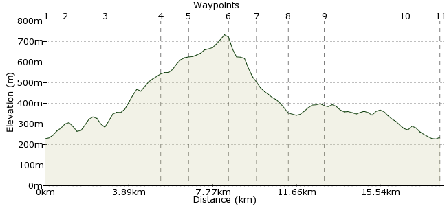
Ascent
571m (1873ft)
Descent
564m (1850ft)
Max. Elevation
740m (2427ft)
Altitude Gain & Loss
1135m (3723ft)
Start & End
Ponterwyd
Distance
18.50km
(11.5mi)
(11.5mi)
Duration
~7:00h
Difficulty
Moderate
Ordnance Survey Map
Walk Functions
Share
Nearby Walks
Along the Afon Rheidol
A leisurely, linear walk (riverside) starting in Ceredigion, Wales, about 6.40km (3.98 mi) long, duration: ~1:45h.Cwm Rheidol Reservoir and Rheidol Falls
A leisurely, walk (low hills and fells (below 600m)) starting in Ceredigion, Wales, about 0.00km (0.00 mi) long, duration: ~0:00h.Gorges of the upper Rheidol and Parson's Bridge
A leisurely, walk (low hills and fells (below 600m)) starting in Ceredigion, Wales, about 0.00km (0.00 mi) long, duration: ~0:00h.Walk Map
- $walk->POI array(0)
Waypoints
OS Grid SN748808
Take the bus to Ponterwyd, on the Aberystwyth-Llanidloes route.
OS Grid SN758810
Take the bridleway towards the B4343.
About 1.03 km (~0.64 miles) from 
OS Grid SN774817
Follow the road to the hotel, then cross over and take the footpath behind.
About 1.68 km (~1.04 miles) from 
OS Grid SN786840
The path crosses the low hills to reach the forest.
About 2.66 km (~1.65 miles) from 
OS Grid SN785851
Continue heading uphill around the edge of the forest and the top is soon in sight.
About 1.12 km (~0.7 miles) from 
OS Grid SN789869
The summit! The highest point in mid-Wales.
About 1.83 km (~1.14 miles) from 
OS Grid SN782879
Drop off the summit on a northwest bearing, heading down the slope of Pumlumon Fach.
About 1.25 km (~0.78 miles) from 
OS Grid SN768873
Drop down to the reservoir and the track alongside it, which will lead you back to the start.
About 1.49 km (~0.93 miles) from 
OS Grid SN761858
In bad weather this will be a long trudge, but when the sun is out it's an easy walk, allowing you to enjoy the stunning scenery.
About 1.65 km (~1.03 miles) from 
OS Grid SN752823
Follow the track to Dinas Reservoir.
About 3.65 km (~2.27 miles) from 
 Ponterwyd again
OS Grid SN747807
Back to the town for the bus home.
About 1.69 km (~1.05 miles) from 
